
JAKARTA
Managing Aquifer Recharge (MAR)
Artificial Aquifer Recharge in Hong Phong District, Binh Thuan Province, Vietnam

- Ho Chi Minh city, June 2006
IN MEMORY OF PROF. PAOLO BONO
In recognition of Prof Paolo Bono's invaluable contribution to the fields of hydrogelogical sciences we take this opportunity to celebrate his life, inexhaustible enthusiasm for research and invaluable commitment to capacity building as well as his exceptional scientific achievements with outstanding integrity, knowledge and great generosity.
Prof. Bono�s contribution to the Vietnamese projects, as a major scientific adviser from 2005 to 2011, focused on training of theoretical and practical aspects of field hydrogeology, hydrogeochemistry and water stable isotopes characterization, through several field investigation campaigns in the Provinces of Binh Thuan, Ninh Thuan, Ninh Binh and Ha Giang.
Prof. Bono passed away in his house in Latina (Italy) on 14 February 2012 and will be dearly missed.
The Project Team:
UNESCO Jakarta
Institute of Geophysics and Institute of Geological Sciences, Vietnamese Academy of Science and Technology, Ha Noi,
Division of Water Resources Planning and Investigation for the South of Vietnam, Ho Chi Minh.
Managing Aquifer Recharge (MAR)
Artificial Aquifer Recharge in Hong Phong District, Binh Thuan Province, Vietnam
NEW!! Please download brochure here!
Introduction
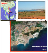 Groundwater is the main source for rural and urban water supplies in South East Asia. Over recent years, increasing extraction to meet rising demand for domestic supplies and irrigation has raised concern for the long-term sustainability of the resource and livelihoods it supports. In other cases the human impact has changed the natural hydrological cycle and threatened already scarce resources. This is the case of Hong Phong District, Binh Thuan Province, South Viet Nam. The Binh Thuan Province, whose principal city is Phan Tiet, is located along the coastal plain in the lower part of Central East Viet Nam and extends for approximately 8,000 km2, with a total population of one million. As massive desertification resulted since 1975, due to both human impact and reduction in rainfall of about 20% in the last 50 years, the area suffers considerable water shortage during the dry season.
In order to fight desertification, best practices on ecosystems rehabilitation as well as remediation techniques to restore aquifer systems and groundwater storage capacity, are been developed in Hong Phong district, located about 25 km NE of Phan Tiet. The project includes three major components, such as a) research and investigation, b) development of a pilot project to supply water for different use, c) capacity building through various international and local training courses/workshops and community involvement in order to sustain the project in the long run.
Lesson learned
Particular attention has been paid to the interpretation of the geological-hydrogeological-environmental asset of the area with particular reference to groundwater occurrences. Important results have been achieved through the investigation, which has been carried out so far:
- Due to the removal of the land cover the piezometric head of the aquifer has risen and outcrops in low morphological depressed area as a consequence of direct infiltration into the sand aquifer during the last 30 years (since the removal of the land cover)
- Groundwater can be abstracted and used after natural filtration for different uses (human and agricultural)
- The particular geo-hydrological asset of the area represented by a semipermeable bedrock and porous material (sand dunes) with a thickness of up to 150 m would allow the use of SAR (Storage and Aquifer Recovery) techniques by conveying rainfall during rainy season and recovery of the resource during the dry period (December-March).
Key messages
The pilot project, currently used by the local community as a water production site (up to 220 m3/day), aims at:
- Demonstrating the potential development of the area through application of techniques able to provide water for both human and agricultural uses,
- Reforestation of the area, to allow original environmental conditions to be re-established (land cover, run-off, base flow)
- The project provides water supply in a desert area where water is not available between December and March
- The innovative techniques used imply bank filtration (as aquifer recharge), never performed before in Viet Nam.
Funding sources:
The project is being funded by the Government of Viet Nam, the Italian Ministry for the Environment Land and Sea, the International Council for Science (ICSU) and UNESCO IHP.
�Impacts of sea level rise by climate change on coastal zone and Islands in Central Part of Viet Nam�
Building on the success of Artificial Aquifer Recharge Project in Binh Thuan Province, the Ministry of Science and Technology (through Vietnamese Academy of Science and Technology (VAST)) requested a hydrogeological investigation into the coastal areas of Ninh Thuan Province, 350 km northeast of Ho Chi Minh, where increasing groundwater salinity occurs in the coastal areas of the province.
In response to the request, the project �Impacts of sea level rise by climate change on coastal zone and Islands in Central Part of Viet Nam� was then launched in the UNESCO-ITALY-VIET NAM WORKSHOP �Adapting to climate Change: Evaluating impacts of sea level rise by climate change on coastal zones and islands: Solution for monitoring saltwater intrusion and sea level rise� which was held from 29 to 30 June 2009 in Ha Noi. For project implementation from 2009 to 2011, the Vietnam Government has allocated 2 million VND (approx. USD 120,000). In addition, the project also was also supported by Italian FIT as part of the �Water Programme for Environmental Sustainability, WAP II�
The increasing groundwater salinity in the coastal area of the province seems is primarily caused by human-induced pumping of brackish water from shallow coastal sand dune aquifers, mainly for irrigation purposes. Moreover, massive industrial salt production could also increase the salinity to the by gravity and diffusion processes. Therefore, the process of salt water intrusion in the coastal area of Ninh Thuan Province will probably spread inland, progressively increasing groundwater salinity locally, even at levels higher than the sea. The problem is compounded by the limited knowledge of the hydrogeological setting and the lack of any assessment of the surface and groundwater resources of the Province. Hydrological monitoring (water level variations and the most important physio-chemical parameters) of selected hydrogeological global systems inland and above all in coastal areas, was therefore recommended to evaluate the existing level of salt intrusion by means of observation wells and detailed geophysical investigations.
In 2009, hydrogeological investigation and drilling campaign were carried out in collaboration with Institute of Geological Sciences, Vietnamese Academy of Science and Technology (VAST). The geophysical campaign was carried out along a defined transect which determines the depth to the base rock, potential discontinuity in the overlain deposits (where the aquifer is located) and extension of the saline/brackish water intrusion in the same. Based on the findings, 3 exploration wells were drilled along the transect and equipped with automatic data acquisition instruments (data loggers) for Electronic Conductivity, Temperature and water level data acquisition.