 |
  |
| |||||
Home to Water Portal
|
|
The Motueka has been classified as a Demonstration HELP basin.
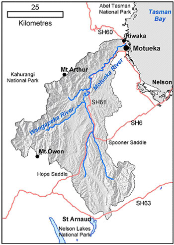 Basin Properties Geographical properties: Motueka River Basin Physical Features
Motueka River Physical Features
Geology
Topography
Seasons & Climatology
Marine resources
Demographic properties: Population:
History of settlement in the Motueka River basin Archaeological evidence suggests that Māori groups first settled the Motueka River area before 1350 A.D. Settlement was largely restricted to the coastal areas, although Māori travelled through the catchment in search of valued �pounamu� or greenstone (argillite). Inter-tribal conflicts decimated the local tribes (iwi) in 1828-1830, about 10 years before the first European settlers arrived. Early European settlers were largely interested in sheep grazing land and in gold. Gold operations existed in the area until the early 1900�s. A major flood in February 1877 transformed the catchment, as a consequence of widespread erosion. Subsequent flooding prompted local river boards to construct stop banks in the lower river in the 1950�s. Introduction of tobacco in the 1920�s brought a period of growth and prosperity. Decline in the tobacco industry in the 1950�s was followed by a rise in fruit tree, berry fruit, and hops and by a rise in commercial forestry. Plantation forests � stocked primarily with exotic species such as Monterey pine (Pinus radiata) and Douglas fir (Pseudotsuga menziesii) were established on less-fertile, steeplands abandoned and purchased from farmers. More recently, vineyards, marine farming, and tourism have added substantially to the diversity and productivity of the local economy. Social & cultural setting New Zealand is a bi-cultural nation, recognising the contributions of both Māori and Europeans (pakeha). The legal document defining the relationship between Māori and pakeha is the Treaty of Waitangi (1840). After languishing for over 100 years, the treaty has served as the basis for recent claims by Māori groups over various land, water and marine resources. Three principal Māori tribes (iwi) are active the Motueka River area and their views and interests are a vital part of this HELP programme. Land uses: Land-use & Land cover
Water resources and uses in the basin: Major Lakes and Bays in Basin:
Major Rivers and Waterways in Basin (* = long term flow data exists):
Hydrogeology
Hydrologic Budget:
Pressures on Water Resources
Policy and legislative properties: Tasman District Council (TDC) serves 45000 residents, and alongside Nelson City Council, is one of four unitary councils acting as both a regional and district council. This combination of local government roles combines all resource management within a single authority, and encourages strong links between service delivery and environmental management. Thus the TDC is a �one stop shop� for local government in its region. Tasman District Council is responsible for sustainable management of land and water and other natural and physical resources of the Motueka Catchment, and its coastal resources up to 19km offshore, under the Resource Management Act 1991 (RMA). The RMA has the objective of promoting the sustainable management of natural and physical resources. It has particular emphasis on protecting the life-supporting capacity of resources, safeguarding the foreseeable needs of future generations and avoiding, remedying or mitigating effects on the environment. Rather than controlling activities such as land use, the RMA emphasises avoiding or limiting the environmental effects of those activities. Tasman District Council has a range of functions relevant to ICM and IWRM, including a mandate for integrated resource management, land management and control of the effects of land use, control of land subdivision, water management, management of contamination, coastal management (shared with the Department of Conservation (DOC)), river and lake management, and natural hazards and hazardous substances management. Tasman District Council undertakes these functions through:
The Tasman Resource Management Plan (Tasman District Council 1996) is divided into six parts, which are at various stages of development: Purpose and Scope; Land Management; Coastal Marine Area; Rivers and Lakes; Water; Discharges. Baseline information availability: The first phase of the Motueka Integrated Catchment Management research programme has concluded with publication of a technical report summarising the present state of knowledge of the catchments, management issues and research needs for integrated catchment management. (Basher et al., 2003). This report summarises the vast amount of information, including metadata and its location, for the catchment. It is available in PDF format for download at http://icm.landcareresearch.co.nz/Library/project_documents/ICM%20Report.pdf Completed research reports, programme management documents, programme planning and events, and more are all available on the Motueka ICM website at: http://icm.landcareresearch.co.nz. Organisations and institutions responsible for Integrated Water Resources Management (IWRM) in the basin: The local and regional environmental and planning agency is Tasman District Council. The national environmental policy agency is Ministry for the Environment. Relevant governmental organisations are:
Statement of Issues, Purpose and Outputs Hydrological and Water Management issues:
Environmental issues:
Livelihoods issues:
Policy and legislation issues:
How do the issues fit with the Five HELP Policy Issues ? Water and Food: In catchments with significant tourism and recreational values, like the Motueka, farmers and foresters are increasingly concerned that increasing land values and pressures from environmental interests could compromise their ability to continue producing food and fibre from productive land � examples of such pressures include limits placed on irrigation pumping, increasing subdivision of productive farms for �lifestyle� owners, and increasing environmental regulation of farming and forestry activities. Water and environment: With about 20% of the Motueka in national park or managed for conservation, plus national recognition for the catchment�s trout fishery, and speleological attributes, the Motueka is a prime example of the tension between catchment management for instream as opposed to out-of-stream values and uses. Water and climate: Both instream and out-of-stream values are affected by summer droughts and extreme flooding. Climate change predictions suggest increased variability of these extremes, so managing for future climate change is a challenge for the council and the community. Water quality and human health: Pathogen levels in the Motueka River increase downstream and after rain due to land use impacts. E.Coli and giardia are particular risks so surface water taken for potable use must normally be treated. An ICM study of campylobacter occurrence throughout the catchment shows heightened risk in tributaries with cattle grazing. Research is being carried out to assess the level of risk from taking groundwater for potable supply from wells near the rivers. Water and conflict: Limits imposed on water extracted from the Motueka River have created tension between existing and potential irrigators, and environmental interests. A lengthy period of negotiation achieved compromise environmental flows and allocation limits in the Water Conservation Order (Motueka River) 2003 recommended for gazettal by the Minister for the Environment. The negotiated limits are now being translated into tributary limits through further negotiation then a formal hearing process. Institutional change and capacity building issues: Having a single council responsible for resource management and service delivery in the Motueka catchment and surrounding areas is a starting advantage. But many catchment residents and some sector groups are suspicious of council�s regulatory motives and some take no notice of the rules. One challenge in the Motueka is to help people have an integrated �ridgetops to sea� appreciation of the effects of resource use with the catchment as a logical management unit. A second is identifying the balance between regulation, education and advocacy, and incentives for achieving sustainability. A third is to develop futures visioning tools to help map future directions towards sustainability. A major focus of the Motueka ICM HELP programme is to maximise council and community involvement in the research projects, thereby applying collaborative learning and action research approaches to sustainable management of the catchment and wider Nelson-Tasman region. Tools to assist with this approach include having Council staff as partners of the ICM research programme, regular meetings of the Motueka Community Reference Group as a sounding board for the research, specific projects with landowner and Landcare groups, subcontracting a landowner liaison role to the local co-ordinator of the NZ Landcare Trust, and a specific research project with the Tasman District Council to identify ways to improve institutional learning. Principal Purposes: Abstract excerpted from the successful Motueka ICM government funding bid and contract 2003: �New Zealand�s Integrated Catchment Management (ICM) research programme is implementing a collaborative learning approach with stakeholders to identify and implement sustainable patterns of land, water and coastal uses, as development pressures increase. Programme goals are:
This programme, begun in 2000 (http://icm.landcareresearch.co.nz/) , will develop and demonstrate a toolbox to guide sustainable management of land and water resources at small to large catchment scales, including the adjacent coast. We have in place a collaboration involving a committed and continuous partnership among researchers, policy makers, resource users, and community members, including iwi. We expect greater satisfaction for all stakeholders in the resource allocation process, less adversarial action, and hence lower costs. The ICM programme is built on four integrated objectives asking the question �What factors under human control will achieve sustainability from ridge tops to the sea in a catchment context?� The four research objectives will answer this by developing and considering:
As the research proceeds, the framework and lessons already learnt in the study site � the Motueka Catchment in Nelson � will begin to be applied in other catchments throughout the country, starting with the Raglan catchment in the Waikato. At an international level, this ICM programme is recognised as one of the inaugural operational pilot basins in the UNESCO/WMO global HELP project (Hydrology for the Environment, Life and Policy).� Principal Outputs: Outcomes excerpted from the Motueka ICM funding contract signed in 2003 are listed below. Expected high level outputs to achieve these are listed in Part III. Knowledge management (Objective 1) 1. A structured organisational learning process available to improve councils� use of science and other information for effective resource management. 2. Better resource management decision-making by stakeholders through a framework that allows accessibility to, recognition and use of knowledge related to the Motueka River catchment and Tasman Bay. 3. Council moving towards an active adaptive management approach for the catchment with monitoring results helping refine integrated model development. 4. ICM programme well interlinked with community and able to track progress of collaborative catchment management through shared model development. Catchment Connections (Objective 2) 1. A robust technique for describing spatial and temporal trends in sediment composition in streams for application in stream health surveys by fisheries biologists and Fish and Game staff. 2. Revision of Tasman District Council water allocation policy for deep aquifers incorporating insights into groundwater recharge from Waiwhero study. 3. Baseline of delta soft sediment habitat condition and health available for assessment of change related to freshwater/land catchment use effects. 4. Data and process understanding available for input into modelling and management scenario analysis (in Objective 4). 5. Methodology available for integrated management of surface and groundwater resources in shallow groundwater aquifers. 6. Implementation of a scientifically defensible means of defining sustainable groundwater extraction levels and appropriate land management policy to protect groundwater resources. 7. Land management policy and practice targeted at reducing sediment impacts on fresh water ecosystem health and marine and aquaculture productivity. 8. Water allocation practice linked with improved knowledge of fish movement requirements, refuge availability and cues for movement. Tools for Management and Policy (Objective 3) 1. The only New Zealand database and knowledge of the below-ground growth performance of native riparian plants which will assist restoration efforts by allowing selection of appropriate species to perform specific functions such as streambank stabilisation. 2. A generic methodology for analysis of river cross-section data and its application to setting gravel extraction limits. 3. Guidance for government and regional councils on determining appropriate levels of community investment in water infrastructure and improved water allocation. 4. A set of protocols or user guides to assist with prioritisation of community-based riparian restoration efforts. 5. Management of water allocation from small streams based on an understanding of potential effects on ecological, aesthetic and cultural values, rather than just historic flows. 6. Guidance for the sustainable planning and management of fish and shellfish resources of Tasman Bay and other comparable coastal sea locations, both in New Zealand and other parts of the world. Visualising Futures (Objective 4) 1. Ability to predict impacts of flood events on factors affecting shellfish sustainability. 2. Framework established to build an integrated ecological-economic simulation model able to be applied in other New Zealand catchments. 3. Real time picture of the growth conditions for shellfish within the Tasman Bay Aquaculture Management Areas. 4. A generic model for simulating sediment generation and transport, the impact of land use and management on sediment generation rates, and sediment effects on freshwater and marine habitats and organisms. 5. A framework of linked models developed and tested using a collaborative learning approach to predict how changes in catchment management influence ecological, economic and social factors throughout the catchment, including coastal areas. 6. Improved understanding of the linkages between ecosystems and land uses within a large complex catchment.
Statement of Proposed Activities Outline of the HELP programme design and plan: The structure of the Motueka ICM HELP research programme integrates across disciplines and environmental media. It aims to mirror the policy development process applied by councils and sector groups in developing environmental management plans and systems. The major activities planned over the next six years, split into the HELP areas, are: Hydrology
Environment
Life
Policy
Measurement and reporting of baseline conditions in the basin: The Motueka ICM programme was built from an in-depth analysis of end-user and stakeholder needs, and reviewed by Prof. Tom Dunne (University of California, Santa Barbara) and Dr Gene Likens (Institute of Ecosystem Studies, New York). An early phase of the research was to summarise existing knowledge about the catchment in a technical report summarising the present state of knowledge of the catchments, management issues and research needs for integrated catchment management (Basher et al., 2003) available at http://icm.landcareresearch.co.nz/Library/project_documents/ICM%20Report.pdf Stakeholder analysis, participation and consultation: The Motueka ICM programme is a primary partnership between Landcare Research, Cawthron Institute and the Tasman District Council. Apart from the involvement of the Council as environmental management agency, stakeholder participation is achieved through:
Capacity building, training and education: The programme is already contributing to building awareness of Integrated Catchment Management as a natural resource management paradigm, through presentations at international and NZ meetings (e.g. the Kalmar HELP conference, the MAF/MfE Water-Lifeblood conference, Asia-Pacific Assn of Hydrology and Water Resources). Within the catchment and region, the programme runs Annual General Meetings plus specific stakeholder meetings to build capacity in integrated management, including training for iwi Maori personnel. In 2007 we plan an international ICM conference and book on the NZ experience with Integrated Catchment Management, probably in conjunction with the NZ Landcare Trust. Schedule of proposed activities: See Milestones in Document attached to this website. Monitoring and evaluation: As this HELP programme is funded largely by the NZ government, they require annual reporting against target milestones and outputs and also against outcomes in the catchment and nationally. Examples of outcomes committed in this programme were given in Part II above. In addition, the programme reports annually to the Council, sector groups and community groups on progress towards achievement of outcomes through the various communication channels mentioned above. By the end of this 6-year programme, a complete review of progress is planned, as a basis for bidding funding for further work either in this catchment or expanded into new ones.
Statement of Commitment Programme or project team members:
Supporting partners and stakeholders:
Provision of resources: The Motueka ICM programme has government funding from the Foundation for Research, Science and Technology committed for the six years from 2003/04 for this programme (contract C09X0305), plus in-kind support and some co-funding from Tasman District Council, Nelson Marlborough Fish and Game Council, Challenger Scallop Enhancement Company, and the mussel industry.
Contribution to promoting HELP values The Motueka has been an inaugural operational HELP basin, and the Motueka Integrated Catchment management research programme operating in the basin since 2000, last year received a further six years� funding, thanks in part to its HELP status and support from Dr Mike Bonell of UNESCO. As New Zealand�s ICM research programme, the Motueka project has generated national interest and discussion of ICM concepts, to the extent that the NZ Landcare Trust has now developed its own ICM project to share best practice among community ICM and Landcare groups. Our Annual General Meetings in October each year attract considerable community and media support � last year attracting over 100 participants at our field day � and the programme has generated an Arts and Science collaborative project based around the idea of �integration� within a catchment setting. Our research results, especially as accessed through our dedicated website at http://icm.landcareresearch.co.nz and the media, are being picked up and promoted by NZ�s 16 regional councils and government departments, including the Ministry for the Environment, Ministry of Agriculture and Forestry, and Ministry of Fisheries. Our experience has generated contract work on water allocation, land-water interactions, land cover effects on water yields, freshwater habitat assessments, and land-marine impacts both within NZ and the Pacific (e.g. recent Fiji and Pohnpei ICM projects). Our HELP-related research has also been presented further afield, e.g. at the Asia Pacific Assn of Hydrology and Water Resources inaugural meeting in Tokyo in 2001 and the Kalmar HELP conference in 2002, the CGIAR Challenge programme and soon at the British Hydrological Society 2004 London conference. The programme has also been recognised through visits by Japanese, Australian and UNESCO visitors. What inputs from other HELP basins are required through technology-transfer and training to achieve the desired project objectives? What inputs could you provide to other HELP basins through technology-transfer and training? The Motueka programme would benefit from exchange of knowledge with other HELP basins, especially in the areas of catchment-scale modelling including how to evaluate economic, social and cultural perspectives in achieving sustainable development. We can share our experiences with ICM (and its subset IWRM) particularly in the Pacific and wider Asia-Pacific areas, and will be looking at what training opportunities could be provided, based on our research experience. Our proposed book and international conference on ICM will contribute to this sharing.
Key contact for this project:
Andrew Fenemor Programme Leader Landcare Research, Nelson New-Zealand E-mail: FenemorA@landcareresearch.co.nz
Links:
|
| | |
|
||||||||||||||||||||||
| ID: 3773 | guest (Read) | © 2004 - UNESCO - Contact |