
NATURAL SCIENCES
Earth Observation
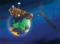
Observation of the Earth is taking place from high above its surface thanks to satellites.
- �GEOSS
Over the last ten years there has been striking progress in the observation of our planet Earth by satellite. And today a large �fleet� of Earth Observation satellites with complementary capabilities is available. Imaging sensors are capable of working at a scale of 1m � 1 km, with radar providing the means to penetrate even cloud cover to sense the surface of the planet. The sinking of cities for example can be measured at an accuracy of >0.01m.
Because Earth Observation satellites remain in place for long time periods, they can detect environmental changes occurring gradually for example: the steady clearing of the world's rainforests; a rise in sea level approaching two mm per year; or the depletion of the ozone layer by atmospheric pollution.
While satellite data are often presented in the form of images, they are actually collected as digital data. Therefore, the same set of raw data can be processed with computer software in many different ways to extract whatever information the end user requires.