
Natural Disaster Reduction
Satellite images - Haiti
Space agencies generously assisting humanitarian, UN and UNESCO activities as an immediate, and sometimes only information available to assess the Haiti earthquake damage.
A selected group of space agencies, conscious of their social responsibility towards the well fare of humankind, have agreed to activate all their satellites when a natural catastrophe occurs.
This was the case of the Haiti�s earthquake. UNESCO, through its strong partnership with the space agencies, obtained satellite information to support UNESCO�s assessment and associated reaction plan to assist Haiti.
The European Space Agency, the French Space Agency (CNES), Geoeye, and Spot Image, generously provided satellite imagery to UNESCO.
Satellite image Haiti earthquake, Port-au-Prince: Governmental Palace
More

Satellite image Haiti earthquake, Port-au-Prince: A stadium
More
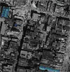
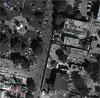
Satellite image Haiti earthquake, Port-au-Prince: downtown
More
