
Natural Sciences
A 4D Geographic Information System to support the conservation of the Calakmul archaeological site and biosphere reserve in Mexico
- � UNESCO/M. Hernandez
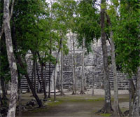
- Calakmul Biosphere Reserve and World Heritage Site
The Calakmul Biosphere Reserve and Cultural World Heritage site is located at the base of the Yucatan Peninsula in Mexico.
Within the framework of a collaboration agreement with UNESCO and in order to help the Mexican authorities to preserve the Calakmul Biosphere Reserve and Cultural World Heritage, the Belgian Science Policy Office (BELSPO) funded the Calakmul 4D Geographic Information System project. This online system will allow the managers of the natural and cultural protected area to store, share, visualize and create interaction between their data, in order to coordinate various conservation, management, planning, monitoring and research activities undertaken in the area.
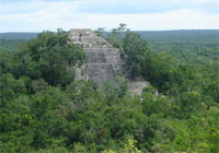
Created in 1989, the 723,185 ha Biosphere Reserve is the largest tropical forest reserve in the country. This biodiversity hotspot shelters rare species of flora and fauna, and is considered to be an important part of the Mesoamerican Biological Corridor. The archaeological zone of 3000 ha was registered as a Cultural World Heritage in 2002. It is an outstanding testimony to the exchange of influences over more than twelve centuries (beginning in the fourth century BCE) in the fields of political organization and cultural development over a vast area of the Mayan region.
Within recent years, settlement pressure, farming, extraction of commercial timber, tourism, among other issues, have threatened this natural and cultural heritage. In order to help the Mexican authorities from the National Institute of Anthropology and History (INAH) and from the National Commission of Protected Natural Areas (CONANP) to preserve it, the Belgian Science Policy Office (BELSPO) funded the Calakmul 4D Geographic Information System project, within the framework of a collaboration agreement with UNESCO. The project's first phase focused on the development and implementation of an �Information Management System� for the conservation authorities of the Biosphere Reserve and Archaeological Urban Centre of Calakmul. This online system will allow the managers of the natural and cultural protected area to store, share, visualize and create interaction between their data, in order to coordinate various conservation, management, planning, monitoring and research activities undertaken in the area.
Earth Observation data from Formosat 2 and SPOT satellites has been used to analyse the evolution of the land use/cover in the area, and to investigate the potential of remote sensing to document Maya ruins and detect evidence of the presence of archaeological remains in a tropical forest environment.
The system was officially delivered to the Mexican authorities on Tuesday, 25 May for implementation. The second phase of the project that will start in the next months will include capacity-building and training courses.
Related links:
:: Ancient Maya City of Calakmul, Campeche (WHC)
:: Biosphere Reserve Information, Calakmul (More)
:: Biosphere Reserves - Frequently Asked Questions (FAQ)
- Source:UNESCO SC
- 27-05-2010
- � Community Tours Sian Ka'an / Manuel Quesada-Ix -