
SERVICES
Twenty-three new biosphere reserves join UNESCO’s Man and the Biosphere (MAB) network
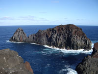
- © F. Cardigos SRAM
- Isla Graciosa, Portugal
The Bureau of the International Co-ordinating Council of UNESCO’s Man and the Biosphere Programme (MAB) has added 23 new reserves sites in 18 countries to its global network. The additions were made by the Bureau during its meeting from 18 to 20 September at Organization Headquarters in Paris.
Changes to two existing biosphere reserves have also been approved. The reserves of Frontenac (Canada) and the Great Volzhsko-Laůslu (Russian Federation) were extended. Meanwhile Germany withdrew the Bayerischer Wald biosphere reserve from the Network because it not longer met the criteria established by the statutory framework adopted in 1995. The Network now numbers 529 sites in 105 countries.
The biosphere reserve concept provides context-specific opportunities to combine scientific knowledge and governance modalities to reduce biodiversity loss; improve livelihoods; enhance social, economic and cultural conditions for environmental sustainability. Biosphere reserves can also serve as learning and experimentation sites.
Below are the new sites approved by the MAB Bureau:
Cape Winelands, South Africa, consists of a mosaic of diverse ecosystems, including the world-renowned Cape Winelands viticultural landscape and part of the Cape Floral Kingdom with some of the most outstanding diversity, density and endemism of the flora of the world. It constitutes an important complementary part of the planned Fynbos Cluster Biosphere Reserve Network. The area is home to more than 300,000 people living in an array of historic towns, hamlets and farmsteads characterized by the distinctive Cape Dutch architectural vernacular.
Noosa, Australia, covers freshwater/tidal and terrestrial areas and straddles two ecoregions (Eastern Australian Rivers and Streams, as well as Eastern Australian Temperate Forests). The site is considered as a "biodiversity museum" critical to maintaining overall biodiversity representation and quality in South-East Queensland. In order to conserve and use in a sustainable way the rich natural and cultural resources of the site, Noosa communities endeavour to manage urban growth in a sustainable manner and develop sustainable tourism strategies in the buffer and transition zones.
Western Nghe An, Viet Nam. Due to the mountainous terrain reaching an altitude of over 2,000m and its remote location, bordering with Laos People's Democratic Republic, the area has a remarkably high biodiversity ranging from lowland monsoonal evergreen forests to elfin cloud forest at altitudes of 2,300m. This site could play an important role in developing the economy and raising the standard of living of the numerous ethnic groups (e.g Thai, Dan Lai, Kho Mu, O Du, H’Mong) living in this area and embodying the country’s cultural diversity.
Marawah Biosphere Reserve, United Arab Emirates. This is the first Biosphere Reserve in the United Arab Emirates. It is of particular importance for the protection of the marine and costal ecosystems and fragile habitats, such as sea grass beds, coral reefs and mangroves. The world’s second largest population of Dugongs finds shelter and food in this site, endowing it global importance. The area is also of significance culturally and archeologically with more than 20 sites dating back to the 16th century in its various islands.
Jabal Al Rihane, Lebanon, represents a green island among wide extensions of bare lands of the semi-arid Bekaa valley to the east and the dry plains to the south. The site, whose name means “mountain of basil,” is specific for its mountainous relief which shelters a number of eco-zones. Besides its ecological values, this landscape of peaks and basins, is of particular aesthetic value as it offers wonderful limitless views and stands of more than 500 years old oak trees are recognized as outstanding scenic landscape.
Manicouagan Uapishka, Canada, lies between the Saint Laurent River in the South and the Manicouagan reservoir in the north. It is visible from outer space from where it has the shape of an eye. Baie-Comeau is the biggest city in the site with 22,613 inhabitants. Numerous rivers cross the territory. Traditionally mining was one of the main activities in this highly forested area. An in-depth participatory process led to a shared vision for sustainable development for the region. The site is also used as a platform for integrating activities across UNESCO’s intergovernmental scientific programmes.
Fundy, Canada, is located on the New Brunswick side of the upper most part of the bay. Some of the earliest colonial settlements in North America were established here. Aboriginal artefacts found in the Bay of Fundy region date back more than 6,000 years. With a total area of 432,000 hectares, including 9,940 hectares of estuarine coastal habitat, the reserves features a very diverse topography, ranging from towering cliffs to broad sweeping salt marshes at the head of the bay. The ‘Fundy Biosphere Regional Network’ stakeholder group has launched innovative practices for sustainable development.
Sierra de Alamos - Río Cuchujaqui, Mexico, is of high importance for the conservation of the fragile desert ecosystems of the Western Sierra Madres and the Northwestern Coastal Plains. Its altitudinal gradient contributes to rich diversity, from low tropical deciduous forests to dense evergreen forests. The mountain range runs parallel to the Pacific Ocean, and has many deep ravines that have been excavated by rivers that flow to the Pacific. The Cuchujaqui River is home to rare felines such as pumas, jaguars, and ocelots. About 400 people live within the Biosphere Reserve and participate in the management of its buffer and transition zones.
Apaneca-Llamatepec, El Salvador, El Salvador’s first biosphere reserve is located in the western part of the country and conserves zones of primary succession mountain vegetation over lava fields. It is a key ecosystem for filtering water that drains into aquifers, benefiting not only the protected area but the entire country. The Santa Ana, or Llamatepec, volcano is the largest volcano in El Salvador (2,381 metres above sea level) and is the nucleus for various neighbouring “parasitic” volcanoes. Shade-grown coffee is an important economic activity for the inhabitants of the area, and the Reserve shows much potential to develop sustainable coffee production enterprises through its innovative participatory practices. Apaneca-Llamatepec is also a dynamic location for field research.
Xiriualtique Jiquitizco, El Salvador, which translates to “place in the bay of stars,” is the largest extension of mangroves in El Salvador and covers transition zones from coastal mangroves to freshwater ecosystems. It includes some of the largest and least fragmented forest areas in the country. The people living in the Reserve have a developed environmental consciousness, especially regarding sustainable production, management of protected areas, risk management, and recovery of traditional ecological knowledge. Sustainable development in the area is based on tourism and the harvest of mangroves, coconuts, sugarcane, fish, and livestock.
Andino Norpatagonica, Argentina, is of high importance for the protection of mountain ecosystems, temperate forests, pastures, and the sub Andean steppe. The area is the easternmost example of Argentine/Chilean temperate rain forests and is recognized by the World Resources Institute and WWF as a Global 200 Site. It is also listed as a biodiversity hotspot by Conservation International. The neighbouring population centres benefit from adventure tourism activities such as sport fishing, skiing, and trekking.
Pereyra Iraola, Argentina, constitutes the last remaining natural habitats along the Rio de la Plata. It is the highest biodiversity and the largest green area in the Buenos Aires Province, home to approximately 12 million people. The watersheds included in the Biosphere Reserve recharge the overexploited subterranean aquifers and are of vital importance in providing clean drinking water to the densely populated areas surrounding the Reserve. The Reserve also protects Buenos Aires’ cultural heritage; its long-time inhabitants still practice traditional dances and produce handicrafts works in leather and wool.
Bosques Templados Lluviosos de los Andes Australes, Chile. Located in the south of the country, this site includes critical high mountain ecosystems and water resources. The coastal temperate rain forests of Chile and Argentina represent approximately 33% of this type of ecosystem in the world. The area is recognized by the World Resources Institute and WWF as a Global 200 Site, and as a hotspot by Conservation International. Local populations are engaged in ecotourism initiatives like trekking. The Biosphere Reserve is contiguous to Argentina’s Andino Norpatagonica Biosphere Reserve and there is potential for a transboundary Biosphere Reserve between the two countries.
Agua y Paz, Costa Rica. Located in the San Juan River watershed, near the Caribbean Sea and the border with Nicaragua, its humid tropical lowland forests are rich in biodiversity and provide habitat for rare species like jaguar and manatee. In addition to Agua y Paz’s mosaic of lakes and navigable rivers, it has wetlands and rafia palm bogs. Its important flooded zones include the Cańo Negro wetland, which is considered the nucleus of the Reserve and is also a RAMSAR site. Agua y Paz Biosphere Reserve assures ecological continuity between Costa Rica’s Cordillera Volcánica Central Biosphere Reserve and Nicaragua’s Indio Maiz Biosphere Reserve.
Podocarpus-El Condor, Ecuador, is located along Ecuador’s border with Peru and conserves important tropical forest ecosystems and water resources. It is extremely rich in biodiversity, largely due to its location where the Amazon, the high Andes, and the Paramo converge. Its dramatic altitudinal ranges (between 700 and 3,790 metres above sea level) create 48 distinct ecosystems and provide critical habitat for many endemic species. Because of recent scientific discoveries, it is one of the highest priority areas for scientific research in the Neotropics. The Podocarpus tree, for which the area is named, is native to the region’s cloud forests. The El Condor mountain range represents Ecuador’s great multiculturalism, ecological and mineral diversity. This biosphere reserve also provides opportunities for sustainable development activities such as organic agriculture and sustainable forestry.
And Atoll, Federated States of Micronesia. Spread over a seascape more than half the size of the United States, the 607 islands and surrounding reefs of the Federated States of Micronesia (FSM) feature an exceptional level of biodiversity. They house mangroves, more than 1,000 species of fish, 350 species of coral, and thousands of species of sponges. And Atoll is one of the last relatively intact seabird rookeries in the region and provides crucial nesting grounds for rare sea turtles. It has the only healthy population of giant clams and has impressive aggregations of grey reef sharks and barracuda. A beautiful island with great vistas and beaches, And Atoll has great potential for ecotourism and is already reputable for diving and snorkelling. Sustainable development alternatives include the production of black peals, giant clams, sponges, and soft coral. Over fishing and hunting are the major threat to the area.
Al-Reem, Qatar, is the first biosphere in the country. It is particularly important for the protection of terrestrial and marine areas and wildlife of great value. Other notable features include elevated limestone formations along the west coast under which lies the Dukhan oil field. Communities residing within the site have managed to preserve biological, cultural and religious aspects from the past while using modern technology to maintain their pastoral and agricultural traditions. Breeding centres are reintroducing native fauna, such as the Arabian oryx and desert gazelle, alongside modern oil and gas pumping stations bringing together conservation of biodiversity and economic development.
Mongol Daguur, Mongolia, in the northeast of the country near the borders of the Russian Federation and Chinese-Mongolia, features a temperate grassland ecosystem with plains, rolling hills and wetlands. It is a nesting and breeding ground for migratory birds along the North-east Siberia - South Pacific migration corridor.
Chebaling, China, in the south of the country, contains relatively well preserved sub-tropical evergreen broad-leaved forests. It is home to the endangered Chinese tiger (Panthera tigris) and the recently rediscovered white-eared night heron (Gorsachius magnificus). Ecotourism is being developed in the context of sustainable development.
Xingkai Lake, China, includes the Chinese part of the largest freshwater lake in Eastern Asia characterized by a mosaic of inland wetland ecosystems with lakes, swamps, plains, and hills supporting a high biodiversity, particularly of fish and bird species. The local population relies on fishing, paper and rice production – ‘Xingkaihu’ is one of China’s green brands - and growing tourism.
Corvo Island, Portugal, is the smallest of the Azorean Islands situated in the extreme northwest of the archipelago, off the coast of Portugal. The island is the emerged part of a volcanic cone (rising 718 metres above the sea) that dominates and shapes the landscape, creating diversified morphology that supports many endemic species. The biosphere reserve includes the island’s entire emerged land mass and surrounding marine area. Centuries of agriculture and cattle breeding have formed a landscape of high cultural significance. The introduction of novel management strategies and the local population’s willingness to participate in experimental community resource management make Corvo Island an exceptional place for research.
Graciosa Island, Portugal, is part of the Azores archipelago. It encompasses the entire island and the surrounding marine area. Graciosa Island is exceptionally geo-diverse; the central volcano (Caldeira) is distinguished by slag and spatter cones, surtseyan cones, basaltic lava flows, sub-volcanic forms, volcanic depressions, caves and algares (gas originated domes). The biosphere reserve includes coastal habitats and evergreen forests and is home to numerous species of endemic birds, bats, molluscs, and arthropods. Agriculture, wine production, and cattle farming are the traditional livelihoods of the inhabitants of this culturally diverse island. Its mild climate, thermal springs, and beautiful landscapes give Graciosa high potential for eco and cultural tourism.
Rio Eo, Oscos y Terras de Buron, Spain, is located in the northwest of the country on the scenic Cantabrian coastline between Asturias and Galicia. The Biosphere Reserve encompasses four distinct landscape units: the estuary and mouth of the Eo River, the Cantabrian coastline, fluvial channels, and the Cantabrian mountain range. The Eo River estuary is an internationally recognized wetland under the RAMSAR treaty and has sustainable development plans for its rational management. Livestock, forestry, and tourism are currently the area’s principle economic activities.
EXTENTIONS
Frontenac Arch Biosphere Reserve (former Canadian Thousand Islands - Frontenac Arch Biosphere Reserve). This biosphere reserve (formerly the Canadian Thousand Islands - Frontenac Arch Biosphere Reserve) named after the explorer who founded the settlement, Count Frontenac, is an area of 2,214 square kilometres. Its continental scale landform, the Frontenac Arch, enables the movement of flora and fauna through the natural barrier created by the Great Lakes and St Lawrence River. The biosphere’s boundaries have been redefined to include, in addition to the two core protected areas (St. Lawrence Islands National Park and Charleston Lake Provincial) a third core protected area, Frontenac Provincial Park, which represents a 30% increase of the total core area as well as the Township of South Frontenac.
Great Volzhsko-Kamsky Biosphere Reserve, Russian Federation. After the designation in 2005 of the Raifa Biosphere reserve and the Sarali Land Between Rivers biosphere reserve, two additional units - Spassky and Sviyazhsky - now complete this ‘riverscape’ biosphere reserve along the Volga River, near the historic city of Kazan in the Republic of Tatarstan at the northern end of the Kuibishev Reservoir, the largest reservoir of Europe. The Spassky unit includes the refuge by the same name with the 64 islands and shallowlands of the Kuibishev Reservoir. The Sviazhsky nature refuge, comprising the valley and fresh-water ecosystems of the mouth of the Sviyaga, a tributary of Volga, islands, gulfs and bypasses. The biosphere now covers a surface area of 151,468 ha. It has cooperation links with the FlusslandschaftElbe Biosphere Reserve in Germany.
- Author(s):Press Release N°2007-109
- Source:UNESCOPRESS
- 20-09-2007