 |
  |
| |||||
Home to Water Portal
|
|
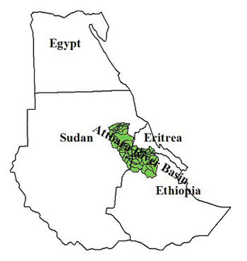
Basin Properties Geographical properties: River Atbara is about 880 km long with the major part of its catchment area in the Ethiopia plateau. The highest level of the Ethiopian plateau is 3500 m amsl, while inside Sudan the region is mainly characterized by a low relief between 580 - 450 m, interrupted by isolated Quarzite and sandstone ridges and Granitic and Basic rock outcrops (Jebels). The total catchment area is 112400 km2. The main branch of Atbara system is River Setit, which has catchment area 68800 Km2. Before the confluence of River Setit with Atbara, there are other branches drain in the system of which River Basalam (Bahar Elsalam) and Upper Atbara are the most important. Basalam and the upper Atbara have a catchment area of 31400km�. River Atbara system is characterized by steep slope and fast flow. This steep slope in addition to the short distance from the source has lead to the fast flow of water with minimum losses as the flood occurs in the same day or the day after rainfall in the Ethiopia plateau. . The average catchment slope inside Ethiopia is about 5m in Kilometer, whereas inside Sudan it decreases to about 1m in kilometer. The effective catchment area of Basalam and upper Atbara tributaries in Ethiopia is 16900 km� and 10700km� respectively, while the total area of the basin in Sudan is 400 km� but most of the water is lost by evaporation and infiltration. Demographic properties: Projection based on different factors of the census department estimates the total population of the Basin in Sudan to be approximately1.5 million excluding refugees in designated camps. The figure include nomads who cross many rural councils and are likely to be overestimated. This also applies to many seasonal agricultural workers who traverse the area many times each year. Average rate of population growth in the area is 3.4%. Population migration is one of the salient demographic features in the basin area. There are three kinds of migrations, namely: nomadic migration, labour migration rural urban migration. More than 80% of the population live in rural areas where the main socio-economic groups are nomads, farmers and agricultural labour. The area of the basin in Sudan is a host of large number of refugees from neighbouring Ethiopia, and they represent considerable part of the population. Some 220,000 refugees entered the basin area inside Sudan mainly of peasant and nomadic background fled drought and conflicts in their home lands. Organised refugees settlements were established in the area since early 1969. However, recently most refugees are encouraged to return. Land uses: The basin lies between the Southern Butana Shrub Savannah and the Southern Gedaref Wood Savannah land regions. Most of the natural vegetation has long been cleared and replaced by mechanized farming. Farming of millet, sorghum and sesame covers much of the gently sloping land. No real balance in natural primary production and resource use. Mechanised farming covers 50% of the basin area for the large production of sorghum and sesame. Animal husbandry, Forestry and Small scale farmers are all threatened. In general agriculture represents 50%, Natural vegetation 28% and Forest resources (subject to added pressure due to accelerated land clearing). Water resources and uses in the basin: The basin is situated in the marginal tropical zone and the annual rainfall is concentrated in a single relatively short summer season. Normally rains can be expected at any time between May and October (the period of river runoff) where approximately 80% of the total rainfall.. However, the length of the rainy season is variable according to the northern movement and subsequent retreat of the intertropical convergence zone (ITCZ). The average rate of rainfall in Ethiopia plateau ranges between 600mm and 1000mm per year while it reaches around 400 in the lower part of the basin inside Sudan. Surface water includes river Atbara and its tributaries, Khors, Hafirs, rainwater harvesting for domestic and agricultural purposes, cisterns, dykes barrages/ dykes. Rivers and Hafirs offer the only methods of surface water utilization in the basin. Small Khors are frequently the source of Hafirs. The area is traversed by many watercourses, notably Atbara, Setit and Bahr As Salam, and two major Khors (Abu Fargha and Samsam) and their tributaries. The annual discharge of the river estimated at Atbara station is 12 Milliard m�/year. Groundwater resources in the basin mainly occur in the deep Nubian sandstone aquifer, which extends over 22,000 Km2. Other secondary water bearing formations are the Basalt and the fractured Basement. Annual recharge to the groundwater aquifers is tentatively estimated between 7 to 29 x 106 m3 with storage capacity estimate ranging between 472 to 7,080 x 106 m3. The absence of Rainwater Harvesting in the Basin, particularly for domestic purposes, is surprising given the acute water shortages in many places. Equally poorly distributed rain is a major agricultural constraint in the basin. In some years this constraint could be alleviated by water harvesting. Policy and legislative properties: There are a number of institutional constraints to the effective implementation of any revised water sector strategy. Baseline information availability: Monitoring of the river inside Sudan is taking place in five station located at Kubur (upper Arbara branch), Wad Elhileiw (Setit branch), Showak (after the confluence of Atbara and Setit), upstream and downstream of Khasm ElGirba Dam and the last station at the downstream end of river Atbara before joining the Main Nile at K3. Data on sediment load and river morphology rather poor and need some proper monitoring facilities such as labs and remote sensing data. Climatic data are available at five key stations well distributed over the basin area. Topographic information available in the basin is not adequate for detailed hydrological studies. Topographic maps scale 1:100,000 covers small part of the area and the rest is covered by 1:250,000 topographic maps. DEMs of high resolution are required. Socio-economic characteristics of the basin need to be updated; however some data associated with recent project of limited part are available from existing NGOs and other relevant institutions. Organisations and institutions responsible for Integrated Water Resources Management (IWRM) in the basin:
Statement of Issues, Purpose and Outputs Hydrological and Water Management issues: The Kerrib Land The Kerrib Country is a land terrain affected by gully erosion along the sides of river Atbara. It extends for long distances along river Atbara valley down to Goz-Gaber village 289 Km from mouth. The Kerrib phenomenon has caused considerable annual loss of arable land of more than 10 km2/y. The present rate of detachment, material transported by runoff to Atbara River is threatening to silt up Khasm el Girba dam. Conservation measures to reduce gully erosion and to urgently protect the dam are crucial to future development of the basin. However, detailed information is needed on the phenomena in-terms of causes and rate of erosion before suggesting any measures to solve the Kerrib problem. Sedimentation River Atbara carries large amount of suspended solids (consist of sand, silt and clay) which moved on the bed level of the river and create sediment problem in Khashim Elgirba reservoir which lost more than 45% of it is capacity as a result of sediment investigation in showak station for river Atbara: the max load of suspended solid 30kg/m3. However the average is 20 kg/m3 at the flood season. There is a plan to construct dams in Atbara and Sitate rivers in addition to wash operation (by opening the sluice gate on the flood season at the second week of August) to reduce the sediment affect on Khashim Elgirba reservoir. River Setate which contributes two third of the total flow of Atbara contain 90% of the total sediment (It reached 86 Milion Tons in 1973). The branch of upper River Atbara before confluence with River Setate contains 8 million Tons /year of the sediment and before the confluence with Basallam contains 3.5 million Ton/year. The main sources of sediment on all dams in Sudan from rivers that has its catchment area on Ethiopia plateau. According to investigation that held on the dam�s reservoir at wash operation period estimated that the samples, which are taken just behind the sluice gate, do not give the accurate indication of sediment load measurement because these samples are taken to get the efficiency of wash operation so it is important to build up measurement station along the river basin. Catchment and source areas require protection and special efforts need to be made to prevent erosion and retain vegetation in these places Groundwater Overdraft Excessive lowering of groundwater table threatens to deplete fossil assets. Water supply issues The WHO standard of 20 liter per capita per day is rarely met in the basin because of shortages or cost. In these situations reasonable personal hygiene standards as part of disease prophylaxis can not be met. Problems related to poor siting, design and management of open water sources are likely to correlate with the high incidence of diseases. Open water sites and contaminated water enable malaria, stomach disease and onchocercias. Likely under reported statistics concluded that every year 20% of the population is treated for Malaria and 10% for gastro-enteritis. Diseases of poverty and malnutrition. Drought issues Atbara Basin is threatened with latest drought episodes causing damage to agriculture and the people livelihood. Downstream user after dam construction After construction of the khashm algirba dam the river flow downstream of the dam reduced to two months instead of 10 months. This fact affected both the socio economics and the livelihood of the area. The minimum environment requirement downstream of the dam is not met. Flooding River Atbara system is characterized by steep slope and fast flow. This steep slope in addition to the short distance from the source has lead to the fast flow of water with minimum losses. Flooding occurs in the same day or the day after rainfall in the Ethiopia plateau. The average rate of rainfall in Ethiopia plateau between 600mm and 1000mm per year while the rate of rainfall between Jun and October (the period of river runoff) is approximately 80% of the total rainfall. The annual discharge of the river at Atbara station is 12 Milliard m�/year. The average rainfall in the upper basin in Ethiopia is 800mm/year, while its 300mm/year in the lower part of the basin inside Sudan. The effective catchment area of Basalam and upper Atbara tributaries in Ethiopia is 16900 km� and 10700km� respectively, while the total area of the basin in Sudan is 400 km� but most of the water is lost by evaporation and infiltration. Monitoring of the river inside Sudan is taking place in four station located Kubur (upper Arbara branch), Wad Elhileiw (Setit branch), Showak (after the confluenc of Atbara and Setit), upstream and downstream of Khasm ElGirba Dam and the last station at the downstream end of river Atbara before joining the Main Nile at K3. Environmental issues: Environmental health The WHO standard of 20 liter per capita per day is rarely met in the basin because of shortages or cost. In these situations reasonable personal hygiene standards as part of disease prophylaxis can not be met. Problems related to poor siting, design and management of open water sources are likely to correlate with the high incidence of diseases. Open water sites and contaminated water enable malaria, stomach disease and onchocercias. Likely under reported statistics concluded that every year 20% of the population is treated for Malaria and 10% for gastro-enteritis. Diseases of poverty and malnutrition. Livelihoods issues: More than 85% of the population is living in rural areas where the main forms of economic activities include Agriculture and livestock husbandary. Livestock husbandry is an important element of the local rural economy and makes a significant contribution to both wealth and income of the region. The livestock both sedentary and nomadic make use of natural resources help to maintain the food security of the area as well as providing a source of export earnings. Policy and legislation issues: Key policy issues in the basin are:
How do the issues fit with the Five HELP Policy Issues? The IWRM issues in the Gash basin fit into the following HELP issues: Water and food The increased productivity/efficiency of water use lead to more crop production that decreases the possibility and vulnerability of the basin to food shortage. Thus, the livelihood of the basin will be improved. Water and environment The key environmental issues in the basins are:
Water and climate
Water quality and human health There is a great tendency that the water supply quality of the basin is affected despite its scarcity. The research will lead to improved water supply quality and quantity. Water and conflict Legislation reforms create major problems between stakeholders. A need for conflict resolution and participation of the stakeholders in the implementation of the reforms. Institutional change and capacity building issues: Key issues are:
Principal Purposes:
Principal Outputs:
Statement of Proposed Activities Outline of the HELP programme design and plan: The Atbara river basin is an excellent example of multi stakeholder interactions where extensive community and organization involvement. These interactions fall under the key HELP research activities in the following areas: Hydrology:
Environment
Livelihood
Policy
Measurement and reporting of baseline conditions in the basin: Atbara River is well documented. There are several available studies which can be made available to the HELP basin. Stakeholder analysis, participation and consultation: Stakeholder involvement will be through farmers associations, Subcatchment Resource Management Programme (SRMP), Pastoralists associations and any other body deemed interested. This can be done through workshops, seminars, public lectures, video shows and exposure international experiences. The UCWR recently conducted a very successful international conference in Rain Water Harvesting in which all stakeholders were involved. Capacity building, training and education: There is a dead need for capacity building (human resource and institutional) especially in this part of the world. UCWR initialized several capacity building programmes that address on job training, programme leading to M.Sc. in Hydrology, Programme leading to M.Sc. in water resources development and management and Ph.D. programme. The capacity building can be achieved through any of the above programmes for the personnel of the related organisations in the use of integrated water resources management tools. Environmental education can be arranged in collaboration with other institutions working in this field. There are areas which need be activated through this project:
Schedule of proposed activities: Year 0:
Year 1:
Year 2:
Year 3:
Year 4 and onwards:
Monitoring and Evaluation: The monitoring and evaluation of the project will be carried out through the related funding bodies through their milestones reports. Six-monthly and annual progress reports will be prepared and reviewed by the research committee of the UCWR and will be made available for HELP initiative. In addition to the research Committee of the UCWR, HELP initiative can assign reviewers and reference panel to enhance the quality of the output. The final outcomes can be published in the web for experience.
Statement of Commitment Programme or project team members:
Supporting partners and stakeholders:
Provision of resources: All the listed team members, partners and stakeholders are involved in the proposed activities. The total funding of the projects involve 1,500,000 us dollars. Part of the funding and expertise will be provided locally and we propose to seek support from donors the following organisations are targeted:
Contribution to promoting HELP values
The Atbara River basin provides an excellent example of community, stakeholders and authorities involvement in hydrological research and development of integrated basin management policies, flood warning system and decision making aide using a range of tools. The basin can serve as an example to illustrate water resources management under competing water uses and environmental and economic concerns. With the help of GIS and the semi distributed modelling techniques in addition to the other tools, flood warning systems, groundwater models, DSS and climatic models will be developed. The study will avail a range of integrated management tools for natural resources management. These tools together with a participatory research and engagement approach will help in developing research priorities and management tools. Consequently, improved land and water management will evolve and through the educational and capacity building tools informed and guided regional and national policies will be setup which will deliver integrated basin management. What inputs from other HELP basins are required through technology-transfer and training to achieve the desired project objectives? What inputs could you provide to other HELP basins through technology-transfer and training? Most of the researchers and organisations are working in dissemination and capacity building centres which will provide good opportunities for wider dissemination of the HELP results.
Key contacts for the project: Prof. Abdalla Abd Alsalam Ahmed Director, UNESCO Chair in Water Resources (UCWR), P.O. Box 1244 Khartoum 11111, Sudan E-mail: chair@sudanmail.net
Dr. Muna Mirghani Ass. Professor, UNESCO Chair in Water Resources (UCWR), P.O. Box 1244 Khartoum 11111, Sudan
Prof. Saghayroon Elzein, Consultant UNESCO Chair in Water Resources (UCWR), P.O. Box 1244 Khartoum 11111, Sudan
Links:
|
| | |
|
||||||||||||||||||||||
| ID: 3727 | guest (Read) | © 2004 - UNESCO - Contact |