Angkor water crisis
bd_site_0668_0058_1.jpg

Have the Angkor Wat temple complex, and the city of Siem Reap, where it is based, become victims of their own success? The tourism boom and an increasing population have resulted in water shortages, forcing the authorities to tap into the groundwater, and dangerously lowering the water table. This poses a threat to the preservation of terrestrial ecosystems and is causing a subsidence of the soil on which the World Heritage Site of Outstanding Universal Value stands. UNESCO, in consultation with international experts and local authorities, is studying the possibility of pumping into the waters of the Tonlé Sap Biosphere Reserve, to ensure sustainable management of water resources and to halt the sinking of the ground on which the temples stand. By Chamroeun Sok
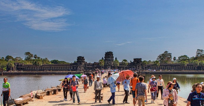
Angkor, one of the world’s most fascinating collection of monuments and temple ruins, is spread over 400 square kilometres within the UNESCO-protected Angkor archaeological park. It has attracted a growing number of tourists since it opened up less than 25 years ago. More than four million visitors — 2.5 million of them foreign tourists — flocked to this unique medieval settlement last year, putting tremendous strain on the area’s scarce water resources.
The Angkor complex, which harbours 112 villages and forests within its boundaries, and the burgeoning town of Siem Reap, a relatively recent development to cater to the booming tourism industry, are in danger of becoming victims of their own success.
With its international airport and an ever-growing population of over one million, besides the tourists that fuel its economy, the provincial capital of Siem Reap has morphed from a sleepy backwater to a bustling town in less than two decades. The city boasts an international airport, over a hundred hotels, restaurants, cafés, and markets full of shops. But the verdant lawns of the five-star hotels and resorts, glitzy new buildings and a fancy golf course come at a heavy price.
Dangerously low water tables
Siem Reap province has a deficit of about 300 million cubic metres of water per year. To compensate for the unbridled development and water shortages, the Siem Reap Water Supply Authority draws about 27,900 cubic metres of groundwater per day for domestic use. Groundwater levels are further impacted by hotels and other businesses, many of whom have sunk thousands of illegal private wells and pumps across the city to meet their water needs.
In Siem Reap, the groundwater is about five metres below the ground surface, and therefore easy to access. This illicit use of water, for which no statistics are available, threatens the stability of the temples and towers of Angkor. The archaeological treasures have been designed to sit on a base of sand, kept in place by a constant supply of groundwater, which rises and falls depending on the season.
Land subsidence is the lowering or sinking of the land surface, and could cause incalculable damage to the temples that have withstood the vagaries of nature and war for a thousand years. Common causes of land subsidence from human activities include the pumping of groundwater underground reservoirs. The lowering of the land level is permanent, even if groundwater levels are recharged. Though there have been no serious problems with subsidence in Angkor yet, and no specific studies have been carried out on this, it could plague the World Heritage Site one day.
Tourism accounts for more than 16% of Cambodia’s GDP, and has helped alleviate poverty in the last two decades of peace, after 30 years of strife. Though there have been efforts to curb the number of residents in the area, it is not feasible to restrict villagers from nearby communities from taking advantage of the tourism-related jobs in the Siem Reap province.
In order to address the challenge of providing adequate water to the province, while assuring the stability of the Angkor temples, UNESCO has partnered with stakeholders. These include ICC-Angkor (International Coordinating Committee for the Safeguarding and Development of the Historic Site of Angkor), a forum of technical experts in various fields; and the APSARA (Authority for the Protection of the Site and Management of the Siem Reap-Angkor Region) National Authority, which runs Angkor Park. The work of these stakeholders, charged with the sustainable development of the site, is beginning to yield some positive results.

© Hang-Peou / Eric Frogé

Tapping into Tonlé Sap
One suggestion to alleviate the water problem is to pump water from the nearby Tonlé Sap (Great Lake). Part of the Tonlé Sap Biosphere Reserve, this is Southeast Asia’s largest lake and one of the world’s most significant wetland ecosystems, due to its unique environmental qualities and extraordinary biodiversity. The variety of fauna and flora of Tonlé Sap is depicted in the bas-reliefs of Angkor’s Bayon Temple. Many of its plant species are used for religious and medicinal purposes by Cambodians. Two million Cambodians also depend on the bounty of the lake’s freshwater fisheries – one of the most productive in the world, with an annual fish harvest of over 250,000 metric tons.
It is crucial for the Cambodian government to weigh the environmental impact before it approves any project to pump water to Siem Reap. The biosphere, which is also the cradle of the Tonlé Sap River, has enormous significance for Cambodians. It acts as a flood mediator for the Mekong River, which flows through five other Southeast Asian countries, so its significance reaches far beyond Cambodia.
Each year, during the rainy season, the Mekong water level rises and overflows into the Tonlé Sap River which, instead of draining the lake as it does during the dry season, is forced to change direction and flow back ‘up’ into the lake. This phenomenon makes the Mekong the only major river in the world to flow in two directions at different times of the year. This annual flood raises the lake level from 1 to 1.5 metres up to 8 to 10 metres, increasing its area fivefold, as it spills out over the floodplain.
One of the world’s great conservation success stories, which includes the revival of several species of endangered birds since protection efforts started in 1999, Tonlé Sap and its floodplain have been listed as the Tonlé Sap Biosphere Reserve under UNESCO’s Man and the Biosphere Programme (MAB).
The 20% year-on-year increase in tourism has also contributed to environmental pollution. Waste control remains an ongoing problem, though many of the temples are swept and cleaned ritually. Rubbish heaps are a common sight in Siem Reap, and tourists and locals think nothing of dumping garbage and waste water directly into the river. Residents living along the Siem Reap river have complained the water is too dirty to use or bathe in. They say that twelve years ago, the water was so clean, they could use it in their homes. Today, the river is dark and dirty, and the water stinks, according to residents.
While Phnom Kulen (“Mountain of Lychees”), twenty-five miles northeast of Angkor Wat, is off the beaten track for the hordes of tourists that descend upon the temples each day, the ill effects of deforestation have eaten into the lush tree cover there. Located upstream, water from the Kulen mountain is another source that flows through the Siem Reap river basin and runs into the Tonlé Sap lake. Here, illegal logging and the planting of cash crops such as cashew trees and beans have adversely affected hydrological patterns in the entire ecosystem, and impacted fish productivity.
UNESCO recently launched a pilot project: “Enhancing and Restoring Water Systems in Angkor World Heritage Site and Siem Reap City”. It uses the sustainability science approach to propose solutions and initiate a sustainable transformation of socio-environmental interactions in the river basin. Policy, legal and institutional frameworks are strengthened through collaborative linkages, learning alliances and targeted interventions for capacity-building at the pilot area, at the national, regional and community levels.
Real cooperation 
The study includes a water campaign to make the residents of Siem Reap aware of the impact on Angkor of the decline in groundwater and the effects of deforestation on the Tonlé Sap Biosphere Reserve.
The sustainable development of water systems in Siem Reap province can be achieved if there is real cooperation between the government, stakeholders and residents. For instance, the government should strictly enforce the logging bans it has put in place on Kulen mountain.
To resolve the critical issue of water management, exact data on basic information like pumping rates, groundwater levels, recharging rates, etc., should be made available and shared between the different local and national agencies involved. This would also enable water-resource planning based on future predictions. Groundwater pumping data would help the accurate prediction of groundwater use, and a groundwater level monitoring system around Angkor could alert all pumping stations and private users to stop and wait for groundwater recovery when critically low levels are reached.
Reviving old systems
People should be educated not throw rubbish or waste into the river. Another initiative could be the restoration of the Siem Reap river to create a tourist attraction and a surface water supply in the future. The restoration of more temples around Angkor could also be used to minimize the wear and tear of increased tourist traffic on the main site.
Recent research has shown that the ancient Khmers who built Angkor a thousand years ago were masters of water engineering. The rulers — who like the administrators of modern cities — had to protect inhabitants from floods in the rainy season, and provide water for domestic use and farming in the dry season, built a range of hydraulic structures that sustained the civilization for six centuries. The sophisticated waterworks included artificial ponds and canals to collect and channel rainwater, barays (constructed reservoirs) to store water for farming, moats, laterite weirs, bridges and dykes.
The Department of Water Management of the APSARA National Authority has conducted theoretical and practical work over eight years, which will allow them to rehabilitate the ancient hydraulic system of Angkor. For instance, the Angkor Thom and Angkor Wat moats which surrounded the temples have been restored and refilled after hundreds of years.
Learn more about

The UNESCO International Hydrological Programme (IHP)

UNESCO and the SDGs

Sustainable Development Goals for Natural Sciences

SDG 6

SDG 15


