
“Silk Roads: Initial Section of the Silk Roads, the Routes Network of Tian-shan Corridor”: China Section

“Silk Roads: Initial Section of the Silk Roads, the Routes Network of Tian-shan Corridor”: China Section
Sites of Central Towns
Site of Weiyang Palace in Chang’an City of the Western Han Dynasty (2nd century BC - 1st century AD)

The Site of Weiyang Palace in Chang’an City of the Western Han Dynasty is the palace remains of the capital city of the Western Han Empire at the early period (2nd century BC - 1st century AD) of the unified imperial history of China, standing on the earliest eastern starting point of the Silk Roads.
Founded in 202 BC, Chang’an city was located on the tableland alongside Wei River in the northwestern suburb of present-day Xi’an, Shaanxi province. Weiyang Palace, as the most important palace of the capital city of Western Han Dynasty, was located in the southwest corner of Chang’an city of the Han Dynasty. The contour of the palace was approximately a square, covering an area of 4.8 square kilometers. Palace gates were built on the four sides of the Palace and turrets on the four corners. There are major east-west and north-south roads crossing the palace area. The front hall, located in the east-central of the palace, was a high-platform architectural complex consisting of several architectures constructed on the same platform. Excavation works have revealed the royal offices, imperial garden area, royal cultural buildings, city wall remains and three city gates. In addition, city moat remains and road remains have also been discovered outside the site of the city.

Jiaofang hall site

Site of Zhicheng Gate of Chang’an city, Han Dynasty
Site of Luoyang City from the Eastern Han to Northern Wei Dynasty (1st – 6th century)

Site of Luoyang City from the Eastern Han to Northern Wei Dynasty hosted the capital cities of four important imperial dynasties in the evolutional history of Chinese civilization (1st Century-6th Century AD), being the oriental starting point of the Silk Roads in this period.
The site of Luoyang city from the Eastern Han to Northern Wei Dynasty was located in the city of present day Luoyang, 15 km west from the city proper of Luoyang and 345 km away from Xi’an city (Chang’an city of Han Dynasty). The layout and remains of the site mainly date back to the Northern Wei Dynasty, accompanied with remains from the Western Jin Dynasty, the Kingdom of Wei and the Eastern Han Dynasty and even from earlier periods. The ancient Luoyang city occupied 10 square kilometers in the Eastern Han Dynasty, and was expanded to a trio of city walls in the Northern Wei Dynasty, covering an area of nearly 80 square kilometers.
Representative remains of Luoyang city from Eastern Han to Northern Wei dynasties were mainly from the inner city at the time of Northern Wei (i.e., the range of Luoyang city in Eastern Han, the Kingdom of Wei, and Western Jin dynasties), mainly containing city walls of the inner city and imperial palace, city gates, remains of the moat, roads remains, and architectural sites (including sites of palaces, government buildings, temples, warehouses etc.) and handicraft workshop sites.

Palace site bird’s-eye view

Yongning Temple pagoda base sites
1. Site of Daming Palace in Chang’an City of Tang Dynasty (7th – 10th century)

The site of Daming Palace is a site of imperial palace that represents the Chang’an City of Tang Dynasty, the east origination of the Silk Roads in its flouring period.
The site of Daming Palace was located on Longshou terrace, north of present-day Xi’an, Shanxi Province, northeast of Chang’an in Tang Dynasty. The Palace was built alongside the north city wall of Chang’an. The construction was launched in the eighth year of Zhenguan (634), but was halted without completion. In the second year of Longshuo (662), the construction continued and was completed next year. Daming Palace was the royal residence and power center of Tang Dynasty. Archaeology proved that the site covered an area of 3.42 square km, with a rectangular south part and ladder-shaped north part. The remains of Daming Palace of Chang’an mainly include: gates remains like Danfeng Gate, palace wall remains, architecture remains like Hanyuan Hall, Linde Hall, Sanqing Hall, Dafu Hall, Wangxian High-Platform Pavilion, water system and bridges remains like Taiye Pool and Longshou branch stream site,roads(including corridors) remains like Yudao Road, and so on.

Hanyuan Hall site

Danfeng Gate site
2. Site of Dingding Gate, Luoyang City of Sui and Tang Dynasties (7th – 10th century)

The Site of Dingding Gate is the site of south gate and blocks of Luoyang City and best represents the city, the east origination of Silk Roads from 7th to 10th century.
The site of Dingding Gate, located in Luoyang city, Henan province in China, consists of remains of south city gate and its blocks in Sui and Tang dynasties (7th-10th century). The property area covers 91.3 hectares. Dingding gate is the south gate on the outer city wall of Luoyang and the south end of the city axis. Dingding gate was built in Sui Dynasty (7th century) in the name of Jianguo Gate, and was renamed Dingding Gate in Tang Dynasty, which name was used till Northern Song Dynasty. Dingding gate was renovated for several times during that period. The east and west sides of the gate were connected with the outer city wall of Luoyang city. The main relics include the remains city wall, Lifang (enclosed residential area, or neighorhood), water system remains and so on.

Dingding Gate site panoramic bird's-eye view


Archaeological finds in Dingding Gate site
3. Site of Qocho City (1st century BC–14th century AD)

Qocho City was the largest central town in Turpan Basin in the southern foot of the Tian-shan Mountains, dating back from the 1st century BC to the 14th century AD.
Qocho City, also known as Iduq-qut, is located in Gucheng village of Erpu Town, 30 km east of the city of Turpan. It was an important resting place on the Tian-shan southern route. The site of Qocho City takes up a total area of about 198 hectares in the form of an irregular square, with three circles of cities. Remains found include city gate remains, Mamian remains (prominent abutment of the wall for defense, like a horse-face), and moat remains out of the city. A Large number of religious building sites and house sites were found in the city. In addition, there are other important sites lying near Qocho City. The two most important remains are: Astana Tombs dating back from the Western Jin to the Tang dynasties (3rd century - 8th century), and the Royal Buddhist temple of Uyghur Qocho kingdom (Kara-Khoja).

Site of Qocho city bird's-eye view

City wall of Qocho city
4. Site of Yar City (2nd century BC– 14th century AD)

Yar (Jiaohe in Chinese) city was an important central town on the Silk Roads from the 2nd century BC to the 14th century.
The ancient city of Jiaohe is located near the village of Yarnaiz, 10 km west of Turpan city. Its location made it extremely important on the Silk Roads- Qocho section. The property area of Yar City covers 680.33 ha. The primary remains include the town site, cemeteries (north and west) and many relics unearthed in the city ruins and graves.The ruined city is located on a terrace 30 meters above the floor of the Yarnaiz Ravine. The terrace is a long leafshaped strip running in a direction southeast-northwest. It is 1750 m long and about 300 m wide. The city covers an area of about 37.6 ha., and is divided into distinct functional sections. There are residential district, an administrative district, warehouse district, a temple district and tomb districts. Cemeteries from different periods are located on the northern and western sides of the terrace, dating from the Jushi Kingdom, and the Jin and Tang dynasties (2nd century BC-8th century).

Yar city site and cemeteries bird's-eye view

Site of Yar city and Tian-shan Mountains
5. Site of Bashbaliq City (7th – 14th century)

Bashibaliq city (Beiting in Chinese) used to be the largest city on the Tian-shan Northern Route of the Silk Roads and a major military, political, and transport center in the area north of Tian-shan Mountains.
The Site of Bashbaliq is situated in Beiting Town of Jimsar County, 12 kilometers north to Jimsar County downtown area, in Xinjiang Uygur Autonomous Region. The site covers 385.15 hectares. Major remains include site of Bashbaliq city, and the site of Qocho Uyghur Buddhist Temple (Beiting West Temple).
The site of Bashbaliq city covers an area of 141 hectares, in irregular rectangular shape of some 850 meters east-west and 1700 meters north-south. Remains discovered in the inner wall and outer wall include: city wall remains, Mamian (bulge wall for defense, in the shape of horse face), turrets, Ditai (similar to Mamian, except that Mamian is dense but Ditai is hollow), city gate, moat, building remains, and road remains. Beiting Qocho Uyghur Buddhist Temple (Beiting West Temple) was located 700 meters west of the site of Bashbaliq City, on the terrace east of the West River. The Buddhist Temple was the royal temple of the kingdom.

Panoramic view of north wall of outer city

Bashbaliq Qocho Uyghur Buddhist Temple site
Sites of Transportation and Defense Facilities
6. Site of Han’gu Pass of Han Dynasty in Xin’an County (2nd century BC – 3rd century AD)

The site of Han’gu Pass of Xin’an County is an important pass remain that the Han Empire built to defend the capital in Central China and was a must gateway for a westward journey from the starting point of the Silk Roads when Luoyang was the capital city of the Eastern Han Dynasty.
The site of Han’gu Pass in Xin’an county is located in Chengguan town of Xin’an county, Luoyang city of Henan province, 23 km west of Luoyang city. Built in 114 BC, the Han’gu Pass was a key transportation hub in Han Dynasty. Han’gu Pass of the Han Dynasty was built along the south side of Fenghuang (Phoenix) Hill, with Qinglong(Dragon) Hill on its south, Kuilou Hill on its west and Badou Hill on its east. Zaojian River flowing through the south of Han’gu pass joined Jian River. Remains of Han’gu pass consist of east-west pass gate tower, rammed earth pass walls on the north and south sides, two Que towers (a freestanding, ceremonial gate tower in traditional Chinese style), as well long walls on the north and south sides of the pass walls.

General view of pass gate tower
7. Site of Shihao Section of Xiaohan Ancient Route (Before 2nd century BC – 20th century AD)
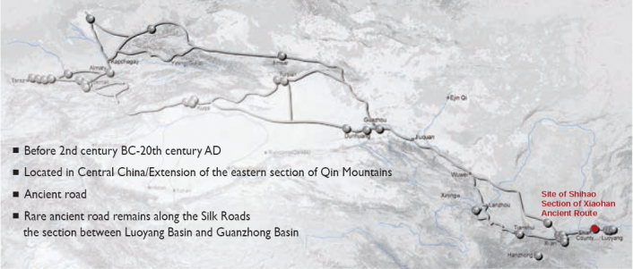
Shihao Section of Xiaohan Ancient Route was part of the Xiaohan ancient route connecting Luoyang and Chang’an, two imperial capital cities of Han and Tang dynasties, providing a rare evidence of the historical support system for the long-distance lasting transportation along the Silk Roads.
Xiaohan Ancient Route refers to the ancient road from Luoyang to Tongguan. The 200 km long Xiaohan Ancient Route was divided by ancient Shan Prefecture (now Shan County) into eastern and western sections, namely, the Hangu section and Xiaoshan section.
The nominated site of Shihao section was on the north route of Xiaoshan section, between Xiashi town and Shihao village, 36 km east of the Sanmenxia city in today’s Henan province. The archaeological work proved that this section of the ancient route has a total length of 1317 meters, consisting three parts. The section that has been unearthed in archaeological excavation is located 800 meters southeast of Chehao village of Xiashi town in Shan county. The northwest - southeast stretching road is 230 meters long, of width varying from 5.2 meters to 8.8 meters. Main remains include limestone road pavement and three roadside water tanks.

General view of Site of Xiaohan Ancient Route

Landscape on the way along the ancient route
8. Site of Suoyang City (About 7-13 Century)

The site of Suoyang City was the transportation hub on the ancient Silk Roads, linking the Central China with the Western Regions.
The site of Suoyang city is located 62km southeast of Guazhou county, Jiuquan city, Gansu province, in the Gobi desert. The property area of Suoyang city covers 15,788.6 hectares. Historical remains include City Remains, Ancient Canal and Reclamation, Tombs and Ta'er Temple.
The City Remains contains the inner city, outer city, and two fortress sites at the northwest corner of the outer city. The inner city and outer city are of irregular square shapes. The inner city covers an area of about 285,000 square meters. Remains of facilities like city gate, barbican, Mamian (horse-faced bulge wall for defense) and turret have been discovered. The Remains of Ancient Canal and Reclamation are distributed around the city, including the dredging system, dams, trunk canal, branch canal, lateral canal and sublateral canal. The Tombs of Suoyang City are located on the south and southeast of the Suoyang City. A total of 2106 tombs have been discovered in an area of 5km north-south wide and 16km east-west long. In addition, the site of Ta'er Temple has been discovered 1km east of the City. It is a large Buddhist temple covering an area of 15,000 square meters.

Inner city of Suoyang city

Close view of Ta'er Temple
9. Site of Xuanquan Posthouse (2nd century BC– 3th century AD)

The site of Xuanquan Posthouse refers to the remains of an important courier station in the Hosi Corridor built in the Han Dynasty during 2nd century BC and 3rd Century AD.
The site of Xuanquan Posthouse was situated at the junction of Dunhuang city and Guazhou county and to the west of Hosi Corridor, on the Gobi sloping fields on the north side of Huoyan Hill, a branch of the Qilian Mountain. Its main function is to pass a variety of mails and information and to entertain passing messengers, officials, official personnel and foreign guests. The site of Xuanquan Posthouse covers an area of 22,500 square meters in which 4675 square meters have been excavated. The site contains complete architectural community remains of the Han Dynasty, including Wubao (fortress), stables, houses and auxiliary buildings outside the fortress and sites of beacon towers in the northwest corner of the Wei and Jin dynasties (3-4 century AD). Post road remains of Han Dynasty were discovered some 20m north of the north wall.

Bird view of Site of Xuanquan Posthouse
10. Site of Yumen Pass (2nd century BC – 3th century AD)

Site of Yumen Pass is the most important pass set by the Han Empire from the 2nd century BC to the 3rd century AD on the west end of Hosi Corridor.
The site of Yumen Pass was located along the Shule River, 90km northwest of Dunhuang Prefecture of Han Dynasty (west of the Dunhuang city today). The site of Yumen Pass is situated in a remote Gobi desert surrounded by a flat landscape and with Caohu Wetland in its north. South of the site was a section of north-south Great Wall, connecting the Yumen Pass with Yang Pass. Major remains of Yumen Pass are: Small Fangpan Castle remains90 (Fangpan refers to its square shape), Big Fangpan Castle remains, remains of Han Dynasty Great Wall and of beacon towers (20 beacon towers and 18 sections of the Great Wall). In addition, relics unearthed in the Yumen Pass sites and surrounding beacon towers include more than 2,400 pieces of bamboo and wood slips, silk products, weapons, firewood, lettuce, farming tools, food, pottery, lacquer, etc.

Remains of Small Fangpan Castle

Remains of the sections of the Great Walls built in Han Dynasty
11. Kizilgaha Beacon Tower (2nd century BC – 3rd century AD)

Kizilgaha Beacon Tower is one of the military communication security facilities on Tian-shan Mountains Southern Route west of Yumen Pass from 2nd Century BC to 3rd Century AD.
The Kizilgaha Beacon Tower is located 12km northwest of Kuqa county downtown, Aksu Prefecture of Xinjiang Uyghur Autonomous Region, on the Gobi terrace east of Yanshuigou Ravine. Many beacon towers have been discovered in Kuqa county. Kizilgaha Beacon Tower, one of them, is the best preserved, the largest and the most representative ancient beacon tower in Xinjiang.
The Kizilgaha Beacon Tower is about 13 meters high. The bottom of the beacon tower is 6.5 meters long from east to west and 4.5 meters wide from north to south. The bottom is rectangular-shaped, and the upper part gradually contracted to become a table-like quadrangular. The beacon tower was built with rammed earth of thickness ranging from 10 to 20 cm. Along the transport route in the mountain range at the south side of Yanshuigou Ravine, there preserves 4 forts of Han and Tang dynasty.

General view of Kizilgaha Beacon Tower

Kizilgaha Beacon Tower
Religious Sites
12. Kizil Cave-Temple Complex (3rd – 9th century)

The Kizil Cave-Temple Complex is the earliest, largest and most influential remains among extant Buddhist caves in the Western Regions. It is one of the most important Buddhist remains along the Silk Roads.
The Kizil Cave-Temple Complex is situated in Kizil Town, Baicheng County, Xinjiang, China. The remains include Buddhist caves, architecture remains in front of the caves. The caves are excavated into the cliff of Mingwutage Mountain in Weigan Valley (named Muzat River Valley near the caves). The Kizil Caves extend from east to west for 1.7 km, scattered on various levels of the cliff. There exist 34994 caves from 3rd century to 9th century with 10000 square meters of murals, a small number of sculptures, and a number of architecture remains in front of the caves. In terms of the cave type, central-pillar Kucha-style Cave is the most typical cave with murals of Hinayana Buddhism theme. The many extant postholes and chiseled traces on the cliff outside caves are remnants of wooden architectures in front of caves.

Exterior of the Caves

Cave New 1, mural of flying apsara.
13. Subash Buddhist Ruins (3rd – 10th century)

Subash Buddhist Ruins were the extant oldest, largest and best preserved Buddhist architectural complex in the Western Regions, continuously used from 3rd century to 10th century.
Subash Buddhist Ruins are located 20 kilometers to the northwest of Kuqa County in Xinjiang Uygur Autonomous Region. The temple complex was built in the 3rd century and gradually turned obsolete after the 10th century. Subash Buddhist Ruins include two areas of temple ruins alongside the banks of Kucha River with a distribution area of 20 ha. The East Buddhist Ruins and West Buddhist Ruins are both comprised of Buddhism Halls, Buddhism Pagodas and Monks’ quarter houses. Some caves are also included in the West Buddhist Ruins. The buildings on the ground are constructed by adobe. The unearthed relics of the Site are of various kinds, including Sarira boxes, silk, ancient coins, pottery, copper ware, iron ware, wood, wooden slips, paper documents and mural fragments to stone statues, clay parts, etc.

Panorama of the Subash Buddhist Ruins

Painting (unrolled) on Sarira Box
14. Bingling Cave-Temple Complex (4th – 10th century)

Bingling Cave-Temple Complex, continuously carved from 4th century AD to 10th century AD, are the caves with earliest history dating inscription along the Yellow River on the Silk Roads with construction year inscribed.
Bingling Cave-Temple Complex is about 52 km away from the southwest of Yongjing County, Linxia Hui Autonomous Prefecture, Gansu Province. They were built from late 4th century (Western Qin Dynasty), continued to be carved between 5th century and 10th century, and maintained in later dynasties of Song, Yuan, Ming, Qing. The main caves consist of 27-meter high Cliffside Great Buddha Cave (No. 171 cave, 27 meters high) of Tang Dynasty on the north of the cliff, and many medium and small caves. There are 185 nominated caves, 776 statues, and murals of 912 square meters. There are 4 caves of Western Qin Dynasty, 40 caves of Northern Wei and Norther Zhou Dynasties, 138 caves of Sui and Tang dynasties, 3 caves of Ming Dynasty and 62 inscriptions.

Exterior of Bingling Cave-Temple Complex

Cave No. 64, Statue of Tang Dynasty
15. Maijishan Cave-Temple Complex (5th – 13th century)

The Maijishan Cave-Temple Complex, built and carved from mid-5th century AD to 13th century AD, is the second largest Buddhist Cave-Temple Complex in Hosi Corridor, only second to the Dunhuang Mogao Caves.
Maijishan Cave-Temple Complex is located in Tianshui city in the east of Gansu province, China. The remains consist of Buddhist cave remains and relevant Buddhist temples and pagoda. The caves, connected by plank ways at various levels, are carved in different layers on the western, southern and eastern cliff of the isolated peak of red sandstone surrounded by mountains, with a lateral range of about 200 meters, as well as a longitude of 20 layers, 10-80 meters high from the ground. There are 198 Buddhist caves built from 5th century to 13th century, over 7000 clay statues, and muralsz of over 1000 square meters. The overall image of Maijishan Cave- Temple Complex with its isolated peak and multi-layer caves, constitute unique landscape together with Danxia Landform and diverse vegetational landscapes around.

Exterior of Maijishan Cave-Temple Complex (Seen from west to east)

Cave No. 127, Murals of city view, Northern Wei Dynasty
16. Bin County Cave Temple (7th – 10th century)

The Bin County Cave Temple is an important Buddhist Temple adjacent to Chang’an, capital of Tang Dynasty, built in 7th-10th centuries at the peak of Central China culture.
Bin County Cave Temple is situated in Chengguan town, bin county, Shaanxi Province. 116 caves were constructed on the sandstone cliff in an area of 400 meters in length on the mountains of the Jing River Valley. The cave carving started from the 5th century (Northern and Southern Dynasties), intensively constructed in 7th- 10th century (Tang Dynasty) as advocated by emperors, and was repaired and maintained in Song, Yuan, Ming and Qing dynasties. The caves are divided into five groups: Great Buddha Cave, Thousand-Buddha Cave, Arhat Cave, Monk's Quarter Cave and Zhangba Buddha Cave, with a total of 466 niches and over 1980 statues. In addition, there are two Jingchuang(Stone Buddhist Pillar), 8 stone tablets, 178 inscriptions, including 24 inscriptions of Tang Dynasty, 68 of Northern Song Dynasty, 2 of Jin Dynasty, 18 of Yuan Dynasty, 65 of Ming Dynasty, and 1 of Qing Dynasty.

Panorama view of Bin County Cave Temple

Big Buddha
17. Great Wild Goose Pagoda (7th – 8th century)

Great Wild Goose Pagoda was built in the 8th century AD to preserve the sutras and Buddhist figurines brought from India by Xuanzang via the Silk Roads. It is the earliest and largest one among extant square pavilion-style brick pagodas of Tang Dynasty.
Great Wild Goose Pagoda is located in Yanta District, Xi’an, Shaanxi province today, i.e. the south of Chang’an city in Tang Dynasty. The Pagoda was built in 652 AD and then was rebuilt in 701 AD. The pagoda we see now is a renovated one in Ming Dynasty (1604). Great Wild Goose Pagoda was a seven-floor square-shaped brick building built on a square brick base. The square base is 45.5-48.5 meters long and 4.2 meters high. The pagoda is 64.1 meters high (pagoda base counted in). The ground floor of the pagoda is 25 meters long with four arches. Two stone tablets were embedded on both sides of the south door, inscribed ‘Da Tang Sanzang Shengjiao Xu’ written by Emperor Taizong and Da Tang Sanzang Shengjiao Xu Ji by Emperor Gaozong.

Great Wild Goose Pagoda, photographed in 2007

"Da Tang Sanzang Shengjiao Xu", Head of Stone Tablet
18. Small Wild Goose Pagoda (8th century)

The Jianfu Temple, where the Small Wild Goose Pagoda was located in, was one of the three sutra translation centers in Chang’an City of Tang Dynasty. Small Wild Goose Pagoda was built in the beginning of the 8th Century and it offers precious evidence of the dissemination of the Buddhist architecture into Central China.
Small Wild Goose Pagoda is situated in Yanta District, Xi’an City, Shaanxi Province. Built in 707 AD of Tang Dynasty, it was also known as Jianfu Temple Pagoda. In the beginning it was a 15-tiers dense-eaves brick pagoda. Having gone through several earthquake damages and restorations in history, the current pagoda has 13 tiers, 43.38 meters high and composed of three parts, viz., the base, the main body and the top. The base of pagoda is a 3.2m-tall square-plan mound built of earth and with brick exterior focades. There also preserves an underground shrine. The body of pagoda is hollow inside with single-layer wall, the inner facade of which is attached by brick steps that lead to the upper floors.

Small Wild Goose Pagoda

Front Gate of Jianfu Temple
19. Xingjiaosi Pagodas (7th – 12th century)

Xingjiaosi Pagodas preserve the Sariras of Xuanzang, the most eminent figure in the history of Buddhism dissemination, and his disciples. It showcased Buddhism's development after its arrival in Chang'an via the Silk Roads and its influence on Korean Peninsula.
Xingjiaosi Pagodas are located in Xingjiao Temple of Du Qu, a small town in the Chang’an district of Xi’an, Shaanxi province, on the edge of the Shaoling Terrace. The West yard of Xingjiao Temple is called the “Ci'en pagoda Courtyard” with three pagodas, arrayed like the shape of the Chinese character “品” roughly triangle. Among them, the Xuanzang Pagoda was built in 669 during the Tang Dynasty. The square pagoda with five floors faces the south. It is 21 meters high with a 5.2m side length of its ground floor. The Kuiji Pagoda was built in 682 (Tang Dynasty). The pagoda is a square three-floor pavilion-style building made of bricks. As for the 7.1m high Yuance Pagoda, it was built in 1115 (Song Dynasty) with the same shape like that of Kuiji Pagoda. Among the three pagodas, Xuanzang pagoda sits in the center, and that of his disciples on two sides, with clear hierarchy.

Xuanzang Sarira Pagoda


Yuance Sarira Pagoda;Kuiji Sarira Pagoda
Associated Sites
20. Tomb of Zhang Qian (2nd century BC)

The Tomb of Zhang Qian is the burial site of Zhang Qian, a celebrated diplomat of Chinese Han Empire (2nd century BC), adventurer and the pioneer for the openning up of the Silk Roads.
The Tomb of Zhang Qian is located in the Raojiaying Village of Bowang Town, 2.3 km west of Chenggu county, Hanzhong city, Shaanxi province. The place is flat terrain on the third terrace of Han River. According to historical records, the tomb of Zhang Qian was built in the 2nd century BC (114 BC, the Western Han Dynasty). Today the cemetery is 100 meters long from north to south and 65 meters wide from east to west. Zhang Qian Memorial Hall is built to the south of the tomb. The cemetry is centered around the earth-covered tomb with brick chamber of the Han Dynasty. Two limestone animal carvings of Han Dynasty face each other south of the tomb standing in the protective pavilion. Four stone tablets stand south of the tomb. The excavation by Northwest United University in 1939 confirmed that it is indeed the tomb of Zhang Qian, Marquis Bo Wang of Han Dynasty.

Bird view of the Tomb of Zhang Qian

Dunhuang mural of Tang Dynasty reflecting the event of Zhang Qian’s diplomatic trip to the Western Regions. The mural is on the north wall of Cave 323 in Mogao Caves


