Article
Drones and great apes, a new story

Project goals
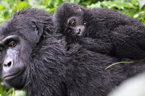
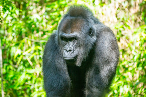
Twenty UNESCO-designated sites from 11 countries on two continents that are home to the three great ape species (gorillas, orangutans and chimpanzees, including bonobos) have committed to the protection of these iconic species.
UNESCO, in partnership with the Muséum National d'Histoire Naturelle (Franc)e and the Sebitoli Chimpanzee Project (Uganda), is launching a new and extensive project to protect great apes and their habitats. Using drones, technicians of these 20 sites will collect data on the phenology of the species, their food sources, the location of any nests, potential areas of conflict with populations, etc., as well as signs of deforestation or habitat fragmentation. The information collected will be pooled in order to have a global view and to make comparative studies. This database on the health and habitat evolution of great apes inside and outside of the areas will allow us to strengthen the protection of our closest cousins by improving our knowledge of their environment.
The use of drones will reduce human disturbance in the study areas and prevent any risk of zoonotic disease transmission to wildlife. Aerial surveys and images allow not only to monitor the natural cycles of the flora (flowering, fruiting, harvesting period...), but also to monitor illegal activities (poaching, mining, etc.) without disturbing the areas.
With a "One Health" paradigm approach to the project, the data collected will establish the link between a healthy environment and healthy apes, thus improving knowledge about apes and allowing for better identification and understanding of the factors and consequences of the threats they face.

A first field training
The first practical field training workshop concluded on January 15 in Kibale National Park, Uganda. It had been preceded by an online workshop that provided representatives from the 20 sites with theoretical knowledge of great ape issues and the use of drones. Twelve technicians from Uganda, Côte d'Ivoire, and Nigeria participated in this pilot workshop facilitated by Dr. Sabrina Krief, a primatologist from the Muséum National d'Histoire Naturelle (France), Mr. Jean Michel Krief, from the Sebitoli Chimpanzee Project, and two drone trainers, Mr. Bruno Roux and Mr. John Plaetevoet from L'Avion Jaune. The MAB Secretariat was also present, as well as the national commission of Uganda for UNESCO and the Ugandan Wildlife Authority.
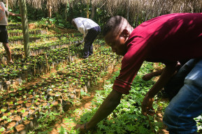
The workshop was meant to be practical, with sessions dedicated to flying drones in real environments to capture images that will feed the common database. It also allowed for a targeted approach to the particularities of each site and each ape population in order to define the survey areas, taking into account the places where ape populations live, the relationships between apes and local populations, the local threats that the animals face, and the technical constraints of the sites: topography of the site, size, internet connection, electricity, etc. Site representatives worked together to define the data collection protocol in order to harmonize data collection across sites.
A second training session for 15 additional sites in Africa and Asia will take place soon.


What next?
Following the training, UNESCO provides each site with a drone, of similar make and model, to assist the sites in the long-term implementation of the project.
The Regional Post-Graduate Training School on Integrated Management of Tropical Forests and Lands (ERAIFT, a category 2 center under the auspices of UNESCO) based in Kinshasa, Democratic Republic of Congo, will host the image database and make it accessible to all. The collection of information will be useful to project participants, but also to scientists who need biodiversity data in the regions, and to governments, who will find it valuable for their reports and contributions to global agendas.
Sites participating in the project
- Cameroon (Dja Biosphere Reserve/Dja Faunal Reserve, mixed site: biosphere reserve and World Heritage site)
- Central African Republic (Basse Lobaye Biosphere Reserve)
- Côte d'Ivoire (Taï Biosphere Reserve/Taï National Park, Comoé Biosphere Reserve/Comoé National Park, mixed sites)
- Democratic Republic of Congo (Yangambi Biosphere Reserve, Luki Biosphere Reserve, and Salonga National Park World Heritage Site)
- Ghana (Bia Biosphere Reserve)
- Guinea (Haut Niger, Ziama, Badiar Biosphere Reserves and Mount Nimba Biosphere Reserve/Mount Nima Strict Nature Reserve, mixed site)
- Malaysia (Crocker Range Biosphere Reserve)
- Nigeria (Omo, Oban and Okwangwo Biosphere Reserves)
- Senegal (Niokolo-Koba Biosphere Reserve/Niokolo Koba National Park, mixed site)
- Tanzania (Gombe Masito Ugalla Biosphere Reserve)
- Uganda (Queen Elizabeth Biosphere Reserve, Bwindi Impenetrable Forest World Heritage Site). Kibale National Park, not a UNESCO-Designated site, is also participating in the trainings as host.