新闻稿

教科文组织新指定18个世界地质公园

联合国教科文组织执行局批准18个地质公园加入世界地质公园网络。由此,网络内地质公园总数达到195个,分布在48个国家。此次增员也使新西兰和菲律宾加入该网络。
Te Kaihīnaki (the Moeraki Boulders) in Waitaki Whitestone UNESCO Global Geopark, New Zealand.

“联合国教科文组织世界地质公园”标识创建于2015年,用于认定具有国际重要意义的地质遗产。地质公园将重要地质遗产的保护、公众宣传、可持续发展方针的落实相结合,服务当地社区。随着这18个新公园的加入,世界地质公园网络成员数量增至195个,总面积达到486709平方公里,相当于英国国土面积的两倍。

新增地质公园为:

卡萨帕瓦联合国教科文组织世界地质公园(巴西)

在巴西土著族群瓜拉尼人眼中,卡萨帕瓦(Caçapava)地质公园就是“丛林的尽头”。它位于巴西最南端的南里奥格兰德州。园内地质遗产(包括开采金属硫化物矿石和大理石)对该地区的经济发展至关重要。卡马夸(Camaquã)盆地的火山沉积物,乃是关于南美地台5~6亿年前从埃迪卡拉纪向寒武纪过渡情况最为完整且出露充分的记录。埃迪卡拉生物群是迄今已知最早的动物。这些海洋软体生物类似于现今的水母等物种。除了地质多样性,该地质公园还是濒危仙人掌科、凤梨科植物,及特有花卉和蜜蜂物种的家园。在座座裸岩山周围,四散分布的原生灌木丛和草原维系着一种可持续生计,即以家庭为单位的绵羊和山羊养殖。地质公园内的山丘风景优美,自中世纪至近代早期一直都是一道天然的军事防御屏障。

Segredo geosite in the Caçapava UNESCO Global Geopark, Brazil
Salso waterfall geosite in the Caçapava UNESCO Global Geopark, Brazil
Guaritas geosite in the Caçapava UNESCO Global Geopark, Brazil

夸塔科洛尼亚联合国教科文组织世界地质公园(巴西)

夸塔科洛尼亚(Quarta Colônia)地质公园地处巴西南部,坐落在潘帕斯草原和大西洋森林生物群落之间。公园名称意为“第四殖民地”,源自意大利人对南里奥格兰德州中部地区的殖民统治时期。彼时,成千上万的欧洲定居者们将他们的希望和梦想寄托于“应许之地”。这片土地毗邻茂密的亚热带森林,绵延于塞拉杰拉尔山脉斜坡上庞大的水系网络冲刷而成的断层深谷之间。这里至今还遗留有殖民时期的别墅,以及前逃亡黑奴(非裔)早期定居点的痕迹,其历史可追溯至数百年前。地质公园内还有大量2.3亿年前的动植物化石。这里曾发现了已知最古老的恐龙化石,包括具有重大国际意义的三叠纪化石。

Paragliding over the Cerro da Figueira Geosite, Quarta Colônia UNESCO Global Geopark, Brazil
Reconstruction of the dinosaurs Buriolestes (at the front) and Bagualosaurus (at the back), part of the Paleontological Exhibition of the Support Center for Paleontological Research in Quarta Colônia UNESCO Global Geopark, Brazil
Visitors at the Quarta Colônia Paleontological Research Support Centre, Quarta Colônia UNESCO Global Geopark, Brazil

拉夫里奥提基联合国教科文组织世界地质公园(希腊)

拉夫里奥提基(Lavreotiki)地质公园以丰富多样的矿物学标本而知名,多个标本的发现属全球首例。这里从混合硫化物矿床中提取的银广为人知。丰富的地质资源使该地区自古以来一直有人居住,目前居民数量为25102人。拉夫里奥提基联合国教科文组织世界地质公园内还座落着拜占庭式的圣保罗使徒修道院。该修道院至今仍在修行传布“东正教修道主义”和进行湿壁画创作,这种传统绘画技法采用由矿石研磨制成的天然颜料进行创作。

Poseidon sanctuary in Lavreotiki UNESCO Global Geopark, Greece
Soureza ancient mining centre in Lavreotiki UNESCO Global Geopark, Greece
Mine No 80 in Lavreotiki UNESCO Global Geopark, Greece

伊真联合国教科文组织世界地质公园(印度尼西亚)

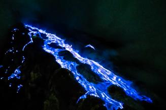
伊真(Ijen)地质公园位于东爪哇省外南梦(Banyuwangi)县和文多禾梭(Bondowoso)县境内。地质公园地处海峡和海洋之间,战略位置优越,因而成为人类迁徙和贸易的要冲。伊真火山是伊真破火山口系统中最活跃的火山之一。破火山口内部及其边缘发育有大约22座后破火山口火山锥。伊真湖是地球上酸性最强的火山口湖,也是同类湖中最大的一个。这里还会上演一种罕见的奇观:高浓度的硫磺从活跃火山口向上溢出,然后与富氧大气接触并发生燃烧;随着气体的燃烧,会喷发出一种独特的蓝色电焰,这种火焰仅在夜间可见。水体本身呈酸性,因为它通过渗透进火山地表之下来实现循环。

Ijen is the most acidic crater lake on Earth and the largest of its kind.
Ijen is the most acidic crater lake on Earth and the largest of its kind. Ijen UNESCO Global Geopark, Indonesia
School trip to Ijen UNESCO Global Geopark, Indonesia
Blue fire can be observed at night in Ijen UNESCO Global Geopark. High concentrations of sulphur rise from the active crater before igniting as they encounter the oxygen-rich atmosphere; as the gas burns, it forms an electric blue flame which is unique and only visible at night.
Blue fire can be observed at night in Ijen UNESCO Global Geopark, Indonesia. High concentrations of sulphur rise from the active crater before igniting as they encounter the oxygen-rich atmosphere; as the gas burns, it forms an electric blue flame which is unique and only visible at night.

马罗斯-庞戈普联合国教科文组织世界地质公园(印度尼西亚)

该地质公园地处苏拉威西岛南臂,位于马罗斯(Maros)县和庞戈普(Pangkep)县境内。当地人口以布吉族和望加锡族土著人民为主。虽然该地质公园面积达
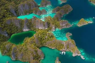
5077平方公里,但其中一半以上(55.4%)隐于水下。公园与主岛隔海相望,园内共有39座岛屿。该群岛散落在珊瑚礁三角区,是一处珊瑚礁生态系统保护中心。地质公园以壮观的塔状喀斯特地貌和斯佩尔蒙德珊瑚礁群岛而闻名。其覆盖区域有着超过亿年的历史;那里留有古代生命形式的痕迹,现栖息着一些特有物种,例如,生活在华莱士线(将婆罗洲岛和苏拉威西岛分隔开来的一条深海沟,以阿尔弗雷德·拉塞尔·华莱士命名,他与同时代的查尔斯·达尔文提出了近似的进化理论)沿线的黑冠猕猴和苏拉威西袋猫。地质公园西侧的土地属于亚洲大陆构造板块,东侧则属于澳洲板块,这也是造成这些相邻岛屿上发现的物种如此多样的原因。

The geopark is known for its spectacular karst towers, seen here from the kalibong aloa cave geosite. Maros Pangkep UNESCO Global Geopark, Indonesia
The Spermonde archipelago serves as a centre for the conservation of coral reef ecosystems. This photo was taken near Kapoposang reef island, in Maros Pangkep UNESCO Global Geopark, Indonesia
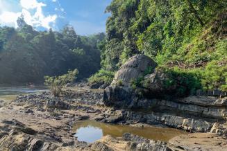
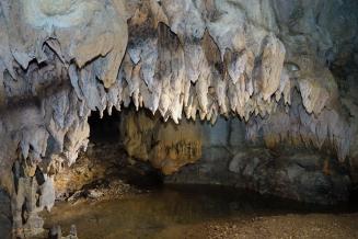
The Leang Salukang Kallang underground river was formed in the longest cave system in this karst area. It is found in the Maros Pangkep UNESCO Global Geopark, Indonesia.

占碑美兰音联合国教科文组织世界地质公园(印度尼西亚)

占碑美兰音(Merangin Jambi)地质公园位于印度尼西亚苏门答腊岛中部,是独特的“占碑植物群”化石的发现地。这些化石是当今世界上唯一出露的该类植物化石,其名称系指在形成于早二叠纪(2.96亿年前)的岩层中发现的植物化石。所含植物包括苔藓、原始针叶树,以及依靠种子而非孢子进行繁殖的种子蕨类植物。公园地势东低西高,最高峰海拔2900米,位于3.3万前的大喷发形成的马苏莱火山群。该地带自史前时代就有人类居住,现还生活着多个土著群体,包括Orang Batin Lamo部落和Serampas部族。地质公园内有形成于中生代(2.52亿-6600万年前)的喀斯特地貌。喀斯特溶洞内留存有史前人类器物,已被纳入一个重要的考古研究项目。

Merangin Jambi UNESCO Global Geopark, in Indonesia, is home to unique fossils of “Jambi flora”, fossilized plants found as part of a rock formation dating from the Early Permian (296 million years old), such as this Araucarioxylon fossil, or petrified conifer.
Karst Complex in the Merangin Jambi UNESCO Global Geopark, Indonesia
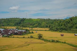
Rice fields in Pulau Tengah Village, Merangin Jambi UNESCO Global Geopark, Indonesia

拉贾安帕特联合国教科文组织世界地质公园(印度尼西亚)

拉贾安帕特(Raja Ampat)地质公园包括4个主要岛屿,其独特之处在于拥有印尼最古老的裸露岩石单元(距今4.438亿–3.589亿年前的志留纪—泥盆纪),岩石单元的年龄几乎是地球年龄的十分之一。最不寻常的地质特征当属在第四纪(258万-1.17万年前)因海平面上升而形成的热带群岛;由于喀斯特作用,这里水面上下均发育出许多溶洞。喀斯特地貌的主体是石灰岩,其质地柔软、多孔隙,可溶于水。随着雨水经年累月地渗入,这种岩石逐渐被侵蚀,继而形成这些溶洞。美丽的水下溶洞和非凡的海洋生物多样性,吸引着大量水肺潜水爱好者。在这里,他们可以观赏到几千年前生活在该地带的史前人类创作的岩石艺术。

Karst of Piaynemo, Raja Ampat UNESCO Global Geopark, Indonesia
The outcrop of low grade metamorphic rock from the Silurian-Devon Ligu Formation, Raja Ampat UNESCO Global Geopark, Indonesia
Scuba-divers flock to Raja Ampat UNESCO Global Geopark, drawn by the beauty of the underwater caves and the extraordinary marine mega-biodiversity. Here in Boo Window Underwater Cave, Misool, Indonesia

阿拉斯联合国教科文组织世界地质公园(伊朗)

该地质公园坐落于伊朗西北部、小高加索山脉南端,北接阿拉斯(Aras)河。小高加索山脉犹如一道天然屏障,不仅造就了多种气候,以及丰富的地质多样性和生物多样性,还是山系南北两侧不同文化之间的联结纽带。公园内最重要的具有国际意义的地质特征,当属2.52亿年前的生物大灭绝事件留下的遗迹。此大灭绝事件是二叠纪与三叠纪的分界线,也是地球历史上最重要的事件之一。公园还是高加索黑松鸡、赤鹿、亚美尼亚公羊和高加索豹等濒危动物的家园,它们栖息在3个保护区内。

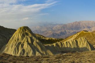
Hoodoos are slim tall columns of sedimentary rocks left by erosion. This Hoodoo, carved from Miocene sediment, is found near the roads leading from Iri to Holaq and to Dastgerd in Aras UNESCO Global Geopark, Iran.
Bandlands geosite in Aras UNESCO Global Geopark, Iran. Badlands are a type of dry terrain where softer sedimentary rocks and clay-rich soils have been extensively eroded, forming a large number of deep drainage channels, separated by short, steep ridges.
The calcite deposits of Gechi Qalasi spring are particularly colorful, featuring yellow, lemon, red, brown and white. It is one of many travertine springs in Aras UNESCO Global Geopark, Iran. The chemical precipitation of calcium carbonate minerals from these springs forms a sedimentary rock called travertine.

塔巴斯联合国教科文组织世界地质公园(伊朗)

塔巴斯(Tabas)地质公园位于南呼罗珊省西北部的沙漠,绵延22771平方公里。这片沙漠被许多饱学之士誉为“伊朗的地质天堂”,这是因为这里可以追寻地球从历史最早阶段的前寒武纪(46亿年前)直至早白垩纪(约1.45亿年前)的演化历程,中间没有丝毫中断。地质公园内坐落着伊朗最大的野生动物保护区——奈班丹野生动物保护区,其面积达150万公顷,是亚洲猎豹最重要的栖息地。公园还占到地区特有药用植物阿魏(Ferula assa-foetida)生长地的一半。该地带历来是贯通伊朗南部、西部与东部、东北部的要道,其宝贵的自然和文化遗产吸引着生态旅游者们慕名而往。

Kal-e-Sardar Geosite, Tabas UNESCO Global Geopark, Iran
Palm Gardens and Nayband Mountain Geosite, Tabas UNESCO Global Geopark, Iran
The ancient village of Korit was severely damaged during the 1978 earthquake. Its important historical heritage has since been valorized. Tabas UNESCO Global Geopark, Iran

白山手取川联合国教科文组织世界地质公园(日本)

白山手取川地质公园位于日本中部,沿着手取川从白山绵延海,记录着约3亿年的地球历史。公园内既有由大陆板块碰撞形成的岩石,也有蕴藏恐龙化石的地层——在日本尚与欧亚大陆相连之时,它们的遗骸堆积于河流和湖泊当中。火山沉积物则形成于约1500万年前的裂解过程中,当时在俯冲板块的牵引下,日本向东漂移,与欧亚大陆逐渐分离。更近期的火山沉积物可追根溯源至白山火山的喷发。白山是日本“三圣山”之一,其火山至今依然处于活跃状态。白山海拔2702米,在与赤道距离相近的山峰中,其降雪量居世界前列。巨大的降雪量推动着水和侵蚀的往复循环,不断塑造地貌景观。

Mount Hakusan, one of Japan’s ‘Three Holy Mountains’, is still an active volcano, rising 2 702 m above sea level. Hakusan Tedorigawa UNESCO Global Geopark, Japan
View of the Shishiku Highlands and the Tedori River alluvial fan. Hakusan Tedorigawa UNESCO Global Geopark, Japan
Watagataki Waterfall was named after the splashing water, which looks like cotton (wata in Japanese). It is the tallest waterfall in the Tedori Gorge, with a height of 32m. Hakusan Tedorigawa UNESCO Global Geopark, Japan

京那巴鲁联合国教科文组织世界地质公园(马来西亚)

该地质公园坐落在婆罗洲岛北端,属沙巴州地界。园内京那巴鲁(Kinabalu)山魏然耸立,它是喜马拉雅山和新几内亚之间海拔最高的山峰,一个多世纪以来一直吸引着探险者们前往探索。地质公园占地4750平方公里,是许多特有动植物的家园,包括仅生长于京那巴鲁山的90种兰花,以及在地球上其他地方均不曾发现的红头鹧鸪鸟。地质公园具有非凡的地质多样性,包括有着数十亿年历史的超基性岩石,这种岩石是地幔的组成物质,但有时也会在火山喷发过程中上升至地表。花岗岩侵入体在地表同样可见——在火山喷发过程中,大多数岩浆始终不曾上升到地表,而是一直在地壳内涌动,最终冷却凝固形成花岗岩等侵入性火成岩。公园的独特地貌景观还包括波令温泉,以及由褶皱和断层沉积岩组成的拉瑙—坦布南地带。

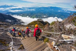
Hikers wearing helmets walk down the slope, high above the clouds and an impressive landscape
Hikers in Kinabalu UNESCO Global Geopark, Malaysia
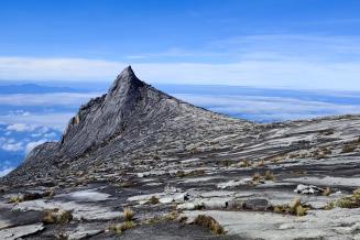
Hornblende Granite peak in the Kinabalu UNESCO Global Geopark, Malaysia. The hornblende granite, characterised by the presence of fine-grained hornblende minerals, occurs on the inner part of the Kinabalu pluton and can be seen along the summit trail from Laban Rata to Low’s Peak.
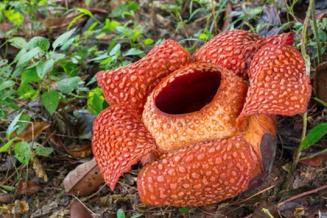
Rafflesia keithii, the largest type of rafflesia in Borneo, in bloom near Poring in Kinabalu UNESCO Global Geopark, Malaysia

怀塔基白石联合国教科文组织世界地质公园(新西兰)

这是新西兰首个联合国教科文组织世界地质公园,坐落在南岛东海岸,从怀塔基(Waitaki)山谷一直绵延至南阿尔卑斯山脚下,面积达7214平方公里。园区内的地貌景观、河流和潮汐,对当地土著人民毛利纳塔胡瓦努伊(Ngāi Tahu whānui)具有巨大的文化意义。该地质公园有助于深入了解地球第八大洲“西兰大陆”(毛利语为“Te Riu-a-Maui”)的历史,提供了关于其形成始末的证据:该大陆先是在约8千万年前从远古超级大陆冈瓦纳古陆分离出来,尔后被淹没在海洋之下达数百万年之久,再后来在构造力的作用下,新西兰被推升至海面之上,该国境内当前的造山运动阶段就此开启。今天,西兰大陆的约94%仍隐没于海洋之下,从新西兰东部向北一直延伸至新喀里多尼亚。

Te Kaihīnaki (the Moeraki Boulders) in Waitaki Whitestone UNESCO Global Geopark, New Zealand. These boulders are formed within sedimentary rocks that had been deposited on ancient seafloor between 50 and 70 million years ago. At the heart of each boulder is a pebble or fossil, around which calcite slowly crystallised. Spherical boulders may have formed around something like a shell, while more irregular boulders may have formed around something much more unique, like the complete 70 myr-old plesiosaur skele
Te Kaihīnaki (the Moeraki Boulders) in Waitaki Whitestone UNESCO Global Geopark, New Zealand. These boulders are formed within sedimentary rocks that had been deposited on ancient seafloor between 50 and 70 million years ago. At the heart of each boulder is a pebble or fossil, around which calcite slowly crystallised. Spherical boulders may have formed around something like a shell, while more irregular boulders may have formed around something much more unique, like the complete 70 myr-old plesiosaur skeleton found at Matakaea (Shag Point).
Elephant Rocks in Waitaki Whitestone UNESCO Global Geopark, New Zealand. Set in a stunning rural vista, these elephant shaped outcrops are formed by Otekaike Limestone, which originated as a fossil rich marine sand 25 million years ago, and was eroded over time by water and wind.
Braided rivers such as the Waitaki River in Waitaki Whitestone UNESCO Global Geopark, New Zealand, only occur in parts of the world with young, rapidly eroding mountains such as the Southern Alps: the reiver transports sediments from the young mountains to the ocean. The river was a primary ara tawhito (traditional travel route) for New Zealand’s indigenous peoples, the Māori.
Māori Rock Art in Waitaki Whitestone UNESCO Global Geopark, New Zealand. The life of local Māori, prior to European arrival can be observed at the Takiroa geosite. Limestone overhangs offered early travellers shelter along a seasonal route up the Waitaki Valley. A variety of rock art is captured here.

桑霍德兰德联合国教科文组织世界地质公园(挪威)

桑霍德兰德(Sunnhordland)地质公园地貌景观丰富多样,既有冰川覆盖的高山,也有沿海滩涂上散落的数千个岛屿。地质景观以其教科书式的样本向世人展示着40个冰期内所发生的冰川侵蚀情况。哈当厄尔峡湾(Hardangerfjord)断层区隔出十亿年的地质演化情况。该地质公园展示了火山系统如何造就大陆:在两个构造板块交汇处,被挤压的板块发生皱缩,然后抬升形成山脉,这个过程称作“造山运动”。地球上最大的造山带中有2条交汇于此。南边是与大陆火山弧(15亿年前)有关的岩石,北边则是来自大洋地壳和岛弧系统(5亿–4.5亿年前)的基岩。

The Bondhus glacier, an arm of Folgefonna glacier, has been reduced dramatically in the last 20 years and is now hardly visible from the trail. Sunnhordland UNESCO Global Geopark, Norway
Visitor centre in Sunnhordland UNESCO Global Geopark, Norway
The Halsnøy moraine, with the Folgefonna glacier on the horizon in the background. Sunnhordland UNESCO Global Geopark, Norway

保和岛联合国教科文组织世界地质公园(菲律宾)

保和(Bohol)岛是菲律宾首个联合国教科文组织世界地质公园,位于米沙鄢群岛。各时期的构造动荡将该岛从海洋深处抬升而起,历经1.5亿年逐渐形成。在构成其典型喀斯特结构的石灰岩中,可以找到该岛地下历史的印记。地质公园内遍布着溶洞、天坑、锥状喀斯特等喀斯特地质遗迹,包括园区腹地闻名遐迩的圆锥形巧克力山。北部海岸的达纳洪双堡礁是东南亚唯一的双堡礁,也是地球上仅有的6个有记载的双堡礁之一。游客们可以在这里一探珊瑚6000年来的生长历史。达纳洪双堡礁由两组大型近海珊瑚礁组成,这些珊瑚礁是在适宜的潮汐流和该地区海底山脊上的珊瑚生长的共同作用下形成。

The uplifted marine terrace in Loon, Bohol Island UNESCO Global Geopark, Philippines. The coastal terrace was raised approximately 1.5 meters vertically and the coastline shifted 50 meters seawards following a 7.2 magnitude earthquake on 15 October 2013. The area is now called “Coral Garden” by the locals.
The three-tiered Can-umantad waterfalls are the highest in Bohol Island UNESCO Global Geopark, Philippines.
Chocolate Hills in Bohol Island UNESCO Global Geopark, Philippines. This unique karst landscape is composed of smooth, conical hills. They are the result of thousands of years of erosion of the limestone on what was once a thick build-up of coral reefs that thrived during the Pliocene approximately 2-5 million years ago.

全北西海岸联合国教科文组织世界地质公园(韩国)

该地质公园充分展现了韩国西部地区25亿年来的地质历史。广阔的潮滩上,火山和岛屿星罗棋布,带着我们穿越时空,拼接起地球历史的碎片。高敞潮滩是世界上19个潮差超过5米的沿海湿地之一。8500年来的沉积形成厚达40米的泥质沉积层,是世界上最厚的潮汐沉积层之一,其中富含全新世(始于1.2万–1.15万年前)沉积物。全北西海岸已被联合国教科文组织认定为世界自然和文化遗产地以及生物圈保护区。此外,该地质公园还被指定为国际重要湿地。

Sunset on Gochang Tidal Flat, Gochang County, Jeonbuk West Coast UNESCO Global Geopark, Republic of Korea
Waterfall in the Jiksofall geosite, Jeonbuk West Coast UNESCO Global Geopark, Republic of Korea
Byeongbawi Rock, Gochang County, Jeonbuk West Coast UNESCO Global Geopark, Republic of Korea

奥特加尔角联合国教科文组织世界地质公园(西班牙)

在这里人们可以探究近4亿年前从地球深处冒出的岩石,从而开启地球内部揭秘之旅。远古碰撞形成了盘古大陆,其过程被称为“华力西造山运动”。奥特加尔角(Cabo Ortegal)地质公园提供了欧洲境内已发现的关于这一运动的一些最完整证据。地质公园内的岩石大多是在劳俄大陆和冈瓦纳大陆的碰撞过程中上升至地表,这两块大陆最终在约3.5亿年前聚合于超级大陆盘古大陆。在碰撞发生之初,这些岩石尚分布在地球的上地幔中,深度超过70公里。从园区矿山中开采到的铜是海底强烈热液活动形成的产物:高温气体和矿物质从被称为“火山喷气孔”的火山烟囱中喷出,然后遇水冷却凝固。

Punta Frouxeira Lighthouse and Virxe do Porto Hermitage, Cabo Ortegal UNESCO Global Geopark, Spa
Punta Frouxeira Lighthouse and Virxe do Porto Hermitage, Cabo Ortegal UNESCO Global Geopark, Spain
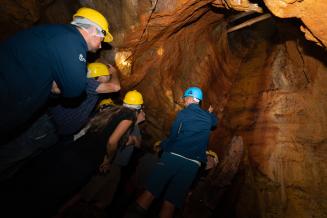
Visit to Piquito Mine, Cabo Ortegal UNESCO Global Geopark, Spain
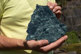
This greenish gray stone is common in Moeche, San Sadurniño and Cerdido. Local populations call it toelo, Moeche stone or serpentine.

呵叻联合国教科文组织世界地质公园(泰国)

该地质公园大部分位于泰国东北部那空叻差是玛府呵叻(Khorat)高原西南边缘的林塔洪河(LamTakhong)流域。这一带的森林类型以落叶龙脑香林为主。该地区独特的地质特征在于化石的多样性和丰富性,其年龄从1600万年到1万年不等。府治县境内已发现大量的恐龙和其他动物化石,如古象化石。另外,那空叻差是玛府乍伦帕革(Chaloem Phra Kiat)县和府治县的沙砾沉积物中也均已发现木化石。基于此,公园自诩为世界“古生命之城”。该地区独特的文化被称为“泰国呵叻文化”。呵叻以呵叻语言、族群和音乐而广为人知,又因在该地质公园发现的新脊椎动物化石物种的学名而闻名于世,例如空阔鳄(Khoratosuchus jintasakuli)和呵叻诗琳通龙(Sirindhorna khoratensis)。

School children look for fossils during an educational activity in Khorat UNESCO Global Geopark, Thailand
Sandstone at Khao Chan Ngam, Khorat UNESCO Global Geopark, Thailand
Sandstone reclining Buddha, Khorat UNESCO Global Geopark, Thailand

莫恩-古利安-斯特兰福德联合国教科文组织世界地质公园(英国)

该地质公园述说着2大海洋在4亿年漫漫地质史中的沧桑变迁。它记录下了巨神海的闭合和北大西洋的诞生,后者导致地壳内部和地表上产生大量熔岩(或岩浆)。由此形成的岩石和地貌尔后又经无数地球进程反复塑造,但其中的主导力量是末次冰期的地球进程。山地和沿海环境的综合作用在这一小片区域形成了少见的极多样冰川特征。这为莫恩(Mourne)山脉和斯特兰福德(Strangford)湖冰川发育和运动的多阶段性提供了证据。该地质公园位于北爱尔兰东南部,毗邻爱尔兰边境,占地面积1932平方公里。人类自末次冰期结束后不久就开始在这一地区居住。

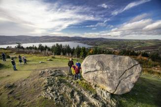
Cloughmore Stone, Mourne Gullion Strangford UNESCO Global Geopark, United Kingdom of Great Britain and Northern Ireland
Fishing for Oysters and Mussels in Carlingford Lough, Mourne Gullion Strangford UNESCO Global Geopark, United Kingdom of Great Britain and Northern Ireland
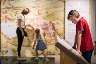
Newry and Mourne Museum at Bagenals Castle, Mourne Gullion Strangford UNESCO Global Geopark, United Kingdom of Great Britain and Northern Ireland

媒体联系人

François Wibaux_Communications Officer
François
Wibaux
Communications Officer

+33 1 45 68 22 93

Clare O'Hagan
Clare
O'Hagan
Senior Press officer

Phone: +33145681729