Revalidation, area modification and renaming
Revalidation
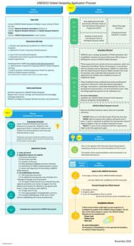
UNESCO Global Geoparks are subject to a thorough revalidation process every four years, to assess their functionality and quality.
The UNESCO Global Geopark under review is required to submit the following documents to UNESCO secretariat. These should be sent via the official channel, as defined by the National Commission for UNESCO or the governmental body in charge of relations with UNESCO.
Documents for revalidation:
- One-page summary of the UNESCO Global Geopark.
To be submitted to the UNESCO Secretariat one year prior to the revalidation, by the end of July. - Progress report of no more than 25 pages, following this template.
This is prepared by the management body of the geopark and submitted by 31 January (three months prior to the field inspection). - Self-evaluation Form A.
Note that Form A was modified in 2021, but both versions are currently accepted. - Progress Evaluation Form B.
A field mission is undertaken by two evaluators to revalidate the quality of the UNESCO Global Geopark. On the basis of the field evaluation report, the UNESCO Global Geopark may receive one of the following:
Green card
The geopark continues to fulfil the criteria. The area will continue as a UNESCO Global Geopark for a further four-year period.
Yellow card
The geopark no longer fulfils the criteria. The management body is notified and has a two-year window to initiate the necessary actions for revalidation.
Red card
The geopark still does not fulfil the criteria, following receipt of a “yellow card” and after the two year period. The area will lose its status as a UNESCO Global Geopark.
Area modification
It is possible for a UNESCO Global Geopark to extend or reduce its boundaries by up to 10% of the existing area. However, all size changes for existing geoparks and new applications are subject to intergovernmental checks.
The request must be submitted during the official submission period, 1 October - 30 November of each year. The request will be displayed for a three-month grace period on the UNESCO website and presented at the annual open meeting of the International Geoscience Programme (IGCP).
The geopark must complete an application form (template), outlining the reasons for the area change and showing that the new area fulfils the UNESCO Global Geopark criteria. In Annexe One, on p. 4, you will be asked to provide a map that accurately locates the UNESCO Global Geopark and the proposed area change. The appropriate map from UN Maps and Geospatial Services must be used here.
The area modification request should be submitted to the UNESCO secretariat, sent via the official channel as defined by the National Commission for UNESCO or the governmental body in charge of relations with UNESCO. The UNESCO Global Geoparks Council may approve or reject the change.
Extensions of over 10% of the existing area are not permitted. A new application must be made following the usual procedure for new applications.
Renaming
A UNESCO Global Geopark may decide to change its name at any point, provided that it secures governmental approval.
To initiate this process, the geopark must send a request to the UNESCO secretariat, via the official channel as defined by the National Commission for UNESCO or the governmental body in charge of relations with UNESCO. If relevant, the National Geoparks Committee should be involved in this process. The geopark in question should provide a document clearly explaining the reasons for the name change (template).
More information


