GATEWAY CITIES OF UZBEKISTAN ON THE GREAT SILK ROADS
Location of Uzbekistan in the center of Eurasian continent allowed it to play a key role in the transcontinental system of the Great Silk Roads. In fact, main routes of the Great Silk Roads uniting East and West passed through the territory of present-day Uzbekistan, which was one of the places, where the first civilizations emerged and developed. Uzbekistan’s territory is characterized by fertile land that is intensively developed by humans, by diversity of raw resources, presence of developed city culture, high level of handicraft industry and commodity-money relations. And it is these factors that predetermined main routes over which trade and exchange relations took place.
Discovery of the Western Regions (i.e. Central Asia) and formation of the Great Silk Roads is associated with the name of Zhang Qian, a Chinese diplomat, who was dispatched by the order of the emperor Wu Di to Bactria in 138 A.D. He was charged with a task of concluding an agreement with the Yuezhi concerning joint actions against the Xiongnu. All together, the whole journey of Zhang Qian to the Yuezhi lasted for more than 13 years. Although he could not persuade the the Yuezhi chieftain to undertake joint actions, he was nevertheless able to gather some valuable information concerning the states and peoples, living in the Western Regions. Consequently, the information obtained by Zhang Qian stirred an interest of the emperor and his functionaries, so that after some time the emperor once again decided to send him with the aim of establishing trade relations in the Western Region. By so doing the emperor was intending to increase Chinese influence there.
In such a way the system of international relations and communications was established, which, later on, was named as the Great Silk Roads.
As a result of these efforts quite close trade and cultural contacts were established with four great powers of the ancient world, i.e. Han Empire, Kushan Empire, Parthian Empire and Roman Empire. With a lapse of time the routes of the Great Silk Roads became the ones, on which not only trade took place, but also cultural relations were established. Along the Great Silk Roads travelled religious missionaries, scholars, musicians and many other individuals. However it should be noted that the functioning of the Great Silk Roads was not always stable and permanent. This was mainly associated with the existing political environment in the regions and countries it passed through. Moreover, the studies conducted on the Great Silk Roads demonstrated that its routes changed their direction at different periods of history. This process could be observed in the example of trade routes, which passed through the territory of present-day Uzbekistan as well. It bears mentioning that the role of the Sogdians in the development of international trade along the Great Silk Roads was significant, which has been confirmed by many written sources and archaeological discoveries made in China and Central Asia. Equally significant was the contribution made by other nations as well, i.e. merchants from Bactria, Dayuan (Davan) and Chach (Shash).
The most intensive periods of functioning of the Great Silk Roads in the territory of Uzbekistan can be observed: in ancient times; when Central Asia became part of Turkic Khanate; during developed Middle Ages.
Reconnaissance and archaeological investigations carried out in the territory of Uzbekistan demonstrate that it is home for dozens of large city centers, related to the antiquity and medieval times, through which the Great Silk Roads passed. However, due to the limited scope of present study, we cannot dwell on them. Therefore we decided to restrict ourselves to the study of four cities located on the borders of the country, through which the routes of the Great Silk Roads led to the neighboring countries. These are the cities of Ahsikent (located in the east), Kanka (located in the north-east, and borders with nomadic steppe), Poykend (located in the west) and Termez (located in the south).
As it is known Yarkand was considered as one of the junctions of the Great Silk Roads. Here the route got divided into two branches, i.e. northern and southern ones. Southern branch through Pamir and Badakhshan led to Bactria and further to the cities of the Middle East and Mediterranean. Northern branch of the route went through Kashgar and various passages and led to the territory of Dayuan (i.e. Ferghana Valley). Initially the route went through Uzgen to Osh. From Osh it passed through the cities of Uzbekistan. In this regard, the largest city of the Ferghana Valley, through which the Great Silk Roads passed, was Ahsikent. The ruins of the ancient site of Ahsikent are located 25 km to the south-west of the city of Namangan, on the right river bank of Syr Darya. Structurally, the ancient site is divided into three parts: a citadel, shahristan and rabad. Total area of the site is about 350 ha. Individual segments of the site have been ruined by Syr Darya by present.
The citadel is located in south-western corner of the ancient site. From north and north-east it adjoins shahristan, which is separated with a deep moat.
Shahristan consists of two parts. Rabad of the city has almost not been preserved except for some individual hilly areas. Notably, the founders of the city, while building it, successfully used the peculiarities of the terrain.
The earliest information concerning the cities of the Ferghana Valley has been preserved in Chinese historical chronicles. The information about them can be found in the medieval written sources as well. Though, it is not so frequent and detailed. Nevertheless, it is of significant interest when it comes to reconstructing historical topography of the cities of Ferghana. In this regard interesting is the information provided by Ibn Hawqal. He wrote, “Ferghana is the name of the country, which represents a vast province that has wealthy cities and settlements. Its capital is Ahsikent. It has a citadel, located in shahristan, near which there is rabad. The palace of the ruler and the dungeon is inside the citadel. Though, а cathedral mosque is not there…The spread of the city is approximately three farsakhs” (Betger, 1975, pp. 25-26).
Obviously, this information is not sufficient to reconstruct the historical appearance of the city. And the results of the archaeological studies, in this sense, could be decisive in finding answers to these kinds of questions.
At present Ahsikent is considered to be the most well studied archaeological monument of the Ferghana Valley. Thus, the excavation works were carried out in almost all parts of this ancient site. And the results of archaeological study demonstrate that at the end of the III – beginning of the II century B.C. in place of Ahsikent a well-fortified city emerged, which had a total area of 40 ha. It included the territories of citadel and shahristan. Already by the II-I centuries B.C. the thicknesses of its walls reaches 20 m. This information allowed A.A. Anarbaev to conclude, that these are the ruins of the capital city of Dayuan (Ferghana), Ershi, which is mentioned in the Chinese historical sources (Anarbaev, 2008, pp. 146-147). The city was intensively rendered habitable in the early Middle Ages as well. During that period it bore the name of “Feghana”.

In the ancient site of Ahsikent the layers associated with Islamic period were well studied thanks to the discovery of municipal buildings, residential areas, manufacturing quarters and centers. In particular, in the territory of shahristan the remains of cathedral mosque and of bath-house, that has a complex planning structure, were discovered. Also, some interesting materials were obtained with regard to existing communication lines and living environment. At the same time particular attention deserves the results of studies which were conducted in handicraft centers specializing in production of damask steel. Indeed, several of such centers were revealed in this ancient site (Anarbaev, 2008). These findings imply that Ahsikent was the city of steel workers and craftsmen, who represented its economic basis. Notably, glazed dishes and goods made of glass, which were manufactured here, stand out with their high quality and refinedness, with their rich assortment and elegant artistic design. And without any doubt, we can assume that significant part of these handicraft products was intended for local and international markets.
The results of the studies indicate that Ahsikent was the largest political, economic and cultural center of the Ferghana Valley in the IX-XIII centuries. At the time the mint of the city introduced coins on behalf of Samanid and Karakhanid governors. However, the city fell to desolation at the beginning of the XIII century. Subsequently, as result of the military campaign of Tatar-Mongols the city was completely destroyed.
After Ahsikent the road went along Syr Darya River and the city of Bap (Pap) to Khodjent. In Khodjent one of its branches went further along Syr Darya River, turned to the north and entered the steppe and Tashkent oasis.
One of the most ancient and largest city centers of Chach (Tashkent Oasis) is Kanka, located 70 km to the south-east of Tashkent and 8 km to the east of the right bank of Syr Darya. The city was the first capital of Chach. Kanka was founded on the left bank of the ancient bed of Akhangaran River, which once flowed into Syr Darya. Total area of the ancient site is not less than 400 ha. It consists of heavily-protected citadel, which is 40 m in height, as well as three shahristans and rabad, which are fortified with strong defensive walls. In the terrain of the ancient site it is possible clearly to observe mains streets, market squares, handicraft quarters, individual residential areas and caravanserais. Kanka is also known under the name of Kharashkent, in other words "the city of farna“ (the fact mentioned in medieval Arabic and Persian sources).
Stratigraphic and plan graphic studies carried out in the ancient site of Kanka under leadership of Y.F. Buryakov allowed identifying main stages in formation and development of the city, understanding its historical topography. The excavations demonstrated that the city emerged in place of the settlement belonging to the middle of the I millennium B.C. and was intensively inhabited until XII century A.D. Initial core of the city was located in place of the medieval citadel, where a complex system of defensive walls as well as some ceramic wares, typical for Hellenistic period, were found (Buryakov, Bogomolov, 2009, p. 70). These discoveries, along with the information obtained from ancient sources, made it possible for scientists to assume, that the emergence of the city in place of Kanka is associated with the campaigns of Demodam, a Seleucid general, against the Saka. Demodam crossed over the river of Yaksart (Syr Darya) and founded the city of Antioch in honor of Seleucid ruler and erected there an altar for Apollo (Buryakov, Bogomolov, 2009, p.71). The next stage in the evolution of the city is associated with the ruling period of Kangju state. Kanka becomes the capital of Yuni possession and of the whole Kangju (III century B.C. – III century A.D.). During this stage large-scale city-planning works take place, monumental royal and cult buildings are erected in the city. Furthermore, handicraft industry is given a renewed momentum, the assortment of the products expands, commodity and money relations develop rapidly. Chach mints its own coins, which are used far beyond the borders of the region. In fact, there is every reason to believe that the mint was located exactly in Kanka. Coins of China and Sogd were found in Kanka, which point to its close trade and cultural relations with neighboring states.
Further growth of the city is associated with its becoming part of Turkic Khanate in the middle of the VI century A.D. Initially Kanka retains its status of political and economic center of Chach Oasis. However, after unsuccessful attempt of the residents of Chach to secede from Western Turkic Khanate in the VIII century A.D., the capital was transferred to the territory of Tashkent (Buryakov and Bogomolov, 2009, p. 73). As a result of this habitable area of the city gets reduced. Nonetheless, the city continues to play the role of large economic center of the region and already by the VIII century the life gets normalized here. Moreover, new manufacturing areas begin to be mastered, associated with different branches of handicrafts. The next stage in the flourishing of the city relates to the XI-XII centuries, i.e. during the ruling period of Samanids and Karakhanids. During this period the city was known as Kharashkent. According to Arabic and Persian sources, it was considered as the second important city from among city centers of Tashkent Oasis after Binkent. During this period the area of the city gets expanded and covers almost 400 ha. If looked from archaeological perspective, it is exactly this time period in the life of the city that is well studied. Thus, the works undertaken shed some light to the planning structure of the city during the last stage of its inhabiting. In particular, a very interesting architectural complex of palace-like nature relating to Karakhanids period was explored in the citadel, residential areas, manufacturing centers and trade shops in the territory of shahristan I and II were studied. Also, a very interesting urban caravanserai was excavated, etc. New materials were obtained concerning civil engineering. The archaeological objects and materials, which were found, point to a high-level of material and spiritual culture of the city people in the IX-XIII centuries. These are wonderful glazed ceramic wares, goods made of glass, and items of toreutics, adornments made from various semiprecious stones and metals, chess pieces and coins. At the end of the XI century life in the city declines because Ahangaran river, which was feeding the city with water, changes its bed. The residents of the city move to Benakent located right on Syr Darya riverside.

Kharashkent, throughout its history, thanks to the international route was closely linked to and practiced active trade relation with China, nomadic steppe and various cities of Sogd and Ferghana.
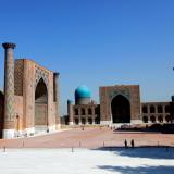
From Khodjent, main route of the Great Silk Roads went to the West, and through Khavas, Zomin and Jizzakh caravans reached the city of Samarkand (the capital of Sogd), which justifiably received the title of “The Heart of the Great Silk Roads”. Samarkand throughout its centuries-long history experienced the times of rise and fall, was subject to devastating incursions of foreign invaders. And every time it revived itself, and became more beautiful and magnificent. In the East, since olden times it was called as “The Pearl of Great Worth”, “Image of the Earth”, “Eden of the East”, “Rome of the East”, “The Blessed City”. This is by far not the whole list of epithets of this city. And it received such epithets thanks to its ancient history, high culture, majestic architectural monuments, wonderful goods created by its craftsmen, great scholars and thinkers, special role it played in the lives of Central Asian and world powers of ancient and medieval times, and of course, due to picturesque nature and its gifts. The most ancient cradle of Samarkand is the site of Afrosiyob, located in the northern part of the modern city. Its total area equals 220 ha. Archaeological studies conducted here allowed identifying its age - 2750 years old. Here magnificent palaces of Samarkand rules of early Middle ages, of Samanid and Karakhanid times, a cathedral mosque, large residential complexes, craft centers and many others were discovered and studied. Archaeological objects found here point to a high-level of artistic culture of the population throughout the whole history of the city.

From Samarkand the route of the Great Silk Roads led to another capital city of Mawarannahr, i.e. the city of Bukhara. And the route between these two cities in the medieval times was called as “Shohrukh” or “Royal Route”. Medieval authors noted that the distance between Samarkand and Bukhara represented 37 farsakhs, so caravans could cover it within 6-7 days. The road passed through densely populated territory of Samarkand Oasis. After Samarkand, caravans went to the city of Rabidjan (Rabinjan) and then to Dabusiya and approached to Karmana and Rabati Malik, located right near the steppe. From Rabati Malik the road went through the steppe, passed the towns of Tavavmsark and Vobkent and led to Bukhara. In Bukhara one branch went to the north, to the oases of Khoresm through Varakhsha, another one – to the west, to Poykend, and further – to Merv. Caravans covered the distance from Bukhara to Poykend in one day.
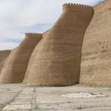
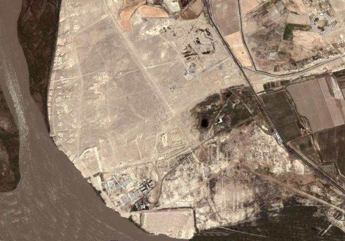
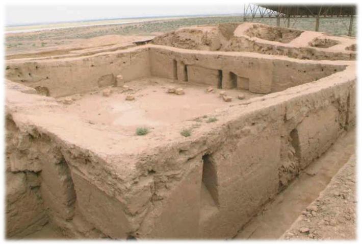
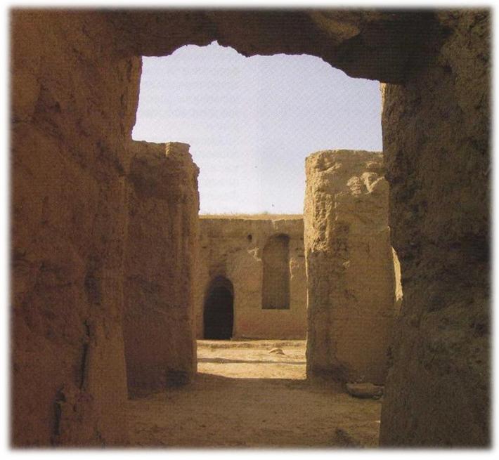
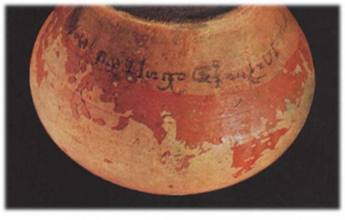
The largest as well as the shortest trade route, which was uniting Bukhara with Merv, passed through Poykend, located on the border with desert areas, 55 km to the south-west of Bukhara (Pic.) Caravans covered this distance in four days (about 20 farsakhs). Ruins of Poykend, in terms of planning structure, represent a rectangle, which stretches from East to West. Total area of the ancient site is 18 ha. Poykend structurally consists of a citadel and two shahristans. Around the city, except for its northern side, there are ruins of many rabads – caravanserais. The citadel with total area of 1 ha is located in the north-eastern part of the city. It was once surrounded by heavily-fortified walls, flanked by projecting towers, and a deep moat. The ruins of the citadel have survived to a height of about 20 m. Shahristan of the city has fortified defensive walls with eight square-shaped projecting towers, which have rectangular loopholes.
Medieval sources have preserved much information concerning Poykend and its surroundings. Particularly noteworthy is the information provided by Al-Tabari, Al-Maqdisi and Narshakhi. In particular, Narshakhi mentions, that near Poykand there was a large lake, into which Sogd River (Zarafshan River) flowed (Narshakhi, 1966, p.25). Also he informs that all residents of Poykand were merchants. They traded with China, were engaged in maritime trade, and therefore were very rich. Narshakhi also mentions about the epithet, which was given to the city - “Shahristoni roin” (“Bronze Shahristan”). Al-Tabari, Al-Khordarbek and Al-Fakih mention another epithet of the city – “Madina al-tudjor” (“The town of merchants”). The sources have preserved valuable information concerning the history and historical topography of the city. Of particular interest is the information provided by al-Maqdisi, who informs that “Boykent is located near Jayhun (Amu Darya) on the border with the desert; it has a citadel with one entrance, inside it there is a crowded bazaar and a mosque, in the mihrab of which there are precious stones; at its foot there are suburbs (rabad), in which there is bazaar”. (Al-Maqsidi, 1906, pp. 281-282). He also provides a list of goods manufactured in Poykend, which were meant for selling. These were various types of soft fabrics, prayer rugs, copper lamps, horse munitions, sheepskin, fat, etc.

According to the information provided by medieval authors, Poykend was one of the richest cities in Mawarannahr. It is noteworthy that information, which was given in the sources, has been confirmed thanks to the archaeological studies carried out in the ancient site of Poykend. In fact, it is one of the few monuments of Uzbekistan, where continuous investigations have been taking place already for several decades. Plausibly, these archaeological works gained a new momentum and rose to a new level during Independence years. As such, fortification systems of the city were studied, public and residential areas, crafts and manufacturing quarters, caravanserais and many other objects were excavated. All these illustrate peculiarities in the development of city planning of Poykend and its surroundings. Found archaeological objects allowed to reconstruct the life and habits existing within the city at different stages of its existence, especially during the last stage.


The results demonstrate that the first inhabited locality in place of ancient site emerged in the IV-III centuries B.C. Already by the III-II centuries B.C. in place of the settlement a small, relatively well fortified stronghold emerges (Adylov, 1988, p. 38). It appears, that erection of the stronghold in this place is associated with vicinity of caravan routes; with the aim of exercising control over strategically important section, i.e. crossing over Amu Darya, through which goods arrived from west to east and vice versa. The city near river crossing was the resting place for caravans before they journeyed further. And it is exactly this advantageous location of the city that became one of the sources of its economic strength. In the IV-V centuries A.D. the first shahristan of the city gets formed. In the V-VII centuries it includes new territories with emergence of the second shahristan (Muhammedjanov, 1988, p. 187). It bears mentioning that during excavation works, along with ceramic wares, terracotta figurines, items made of iron, etc., Chinese bronze coins of Tan dynasty were found.
The most intensive growth period of the city falls on the Early Middle Ages. It appears that is was due to intensification of relations on caravan routes and strengthening of the role of the city in this process.
At the beginning of the VIII century A.D. Poykend was significantly damaged during Arabs’ campaign to Sogd. The traces of this destruction were clearly identified during archaeological works. The results of these works also demonstrated that the Arab conquest, creation of a large centralized state, the Arab Caliphate, and assuming of power by representatives of local nobility on site, had a positive impact on consequent political and economic life of the city. Poykend within short period of time freed itself and recovered its status. However, defensive walls lost their former importance, as evidenced by the discovery of ceramic workshops and residential houses in place of defensive walls. Ceramic wares and glass items of Poykand in terms of quality and artistic design could compete with those manufactured in various handicraft centers. Here the most ancient drugstore in the whole Mawarannahr was discovered (Muhammedjanov, 1988, p. 89). At the end of the X century A.D. the city gradually declines. Soon the life in Poykend fades away. This was associated with shallowing of Zarafshan River, the water of which, since olden times, had been feeding the city and its surroundings.

One of the active routes of the Great Silk Roads from Samarkand went to the south-west, in the direction of Kesh and near Guzar turned to the south, in the direction of mountainous region, and through the passage of Akrabat reached “Dar-i-ahanin” (“Iron Gates”), where there was a border between Sogd and Bactria. Here there was a border between Kangju and Kushan Empire. From “Dar-i-ahanin” (“Iron Gates”) the road went along Sherobod Darya and led to the city of Sherobod, located on the flatland, from where it went further to the south, to the Valley of Amu Darya and the city of Termez. Termez was one of the most ancient and largest cities of the East.
The city of Termez emerged in the middle of the I millennium B.C. in place of Amu Darya (Oxus) River crossing. It played an important role in the history of many powers of the Middle East, of antiquity and Early Middle Ages. Location of the city on strategically important section of the river and on intersection of trade routes going from north to south, from east to west, facilitated its rapid growth and development. One of the branches of the Great Silk Roads passed through Termez. And the role of the city as an important point, located near the river crossing, was a defining factor in its history. Maybe that is one of the reasons as to why, Termez, even nowadays, is considered southern gates of Independent Uzbekistan.
Ruins of Old Termez are located 7 km to the north-west of modern city, along the right bank of Amu Darya River. The ancient site consists of three parts: a citadel, shahristan and rabad. Each of these was fortified with powerful defensive walls. The citadel, or Kuhendiz, was located in the south of the ancient site, right near the bank of Amu Darya River, on the naturally formed sandstone hill. Tall and massive walls of the citadel could be observed from all sides, which point to former strength and greatness of the city. To the north-east of the citadel there was shashristan. Further to the east of shashristan, stretched a huge territory belonging to rabad, where major trade and handicraft centers were located. Unlike other medieval cities of the East, to the east of rabad there was a special territory called “suridikat”, where there was a country residence of Termez rulers of the XI-XII centuries A.D. Total area of the ancient site is almost 500 ha.

The ancient name of the city was Tarmita. The word is derived from ancient word Taramaetha, found in Avesta, and means “the settlement on the other side of the river”. Alexander the Great changed its name to Alexandria on the Oxus. During Seleucid rule the city bore the names of Antioch and Tarmita. In the Armenian sources belonging to the Early Middle Ages, it was known under the name of “Drmat”. Chinese traveler and pilgrim, Xuanzang, who visited the city in 630 A.D., calls it Tami. In Arabic and Persian sources of the IX-XIII centuries it is possible to observe different spellings of its name, such as Tarmiz, Tirmiz or Turmiz.
Medieval sources have also preserved valuable information concerning historical topography of medieval Termez. In particular, authors of the end of the IX century, Ibn Khordadbeh and Ibn Qudamah, inform that Termez was located on the cliff near the river, which washed its walls. Nevertheless, it is Al-Istakhri, who provides the most detailed description of Termez. He notes that the city consisted of a citadel, city itself (shahristan) and suburbs (rabad). He further writes that the palace of the ruler was located inside citadel, the dungeon – in shahristan, somewhere in bazaar. Here was also a cathedral mosque, though Namozgoh mosque was inside rabad. He also mentions that the streets and squares of the city were paved with burnt bricks. The city had a large population, served as a harbor on Jayhun (Amu Darya) River, to which ships from various places sailed. Almost identical information was provided once again by the authors of the XII-XIII centuries. It bears mentioning that the remains of the harbor in the form of a lengthy monumental building, located along southern face of the citadel, with tower-like rectangular projections made from burnt bricks that were laid on waterproof solution (kyr), have been preserved to our days. The projections are located at a certain distance from each other and they form an original bay for ships.
Termez is considered to be one of the most well studied monuments of the south of Uzbekistan. The results of archaeological studies carried out in the ancient site allowed to reconstruct the historical appearance of the city at different stages of its existence. The studies further demonstrated that already by the III-II centuries B.C. in place of Termez there was a big city, which occupied the area of more than 10 ha. It became the main outpost on the northern borders of Greco-Bactrian Empire and was considered one of “thousand cities of Bactria”, as reported by ancient authors. The city represented a large economic and cultural center of Northern Bactria. Here figurines made of ivory and fragments of glass vessels of Egyptian origin were found. This fact allows to conclude that Termez, well before the Great Silk Roads was formed, had had close trade contacts with India and the Mediterranean cities. During the Yuezhi period Temez became the headquarters of the Guishuang tribe, the rulers of which minted the coins resembling tetradrachm of the last Bactrian ruler, Heliocles. In favor of this assumption speaks the abundance of coins of this type, which were found in the ancient site.

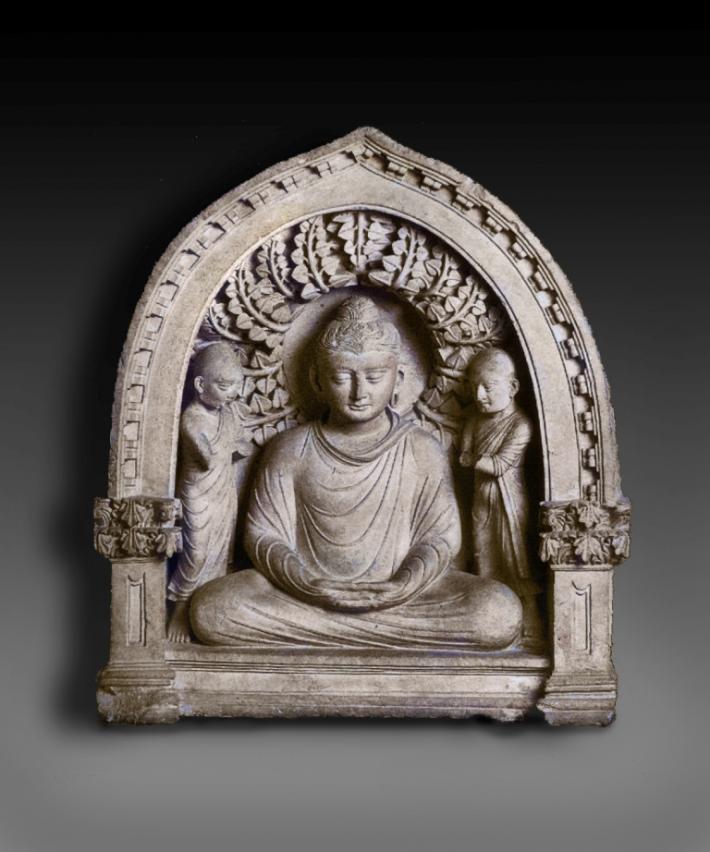
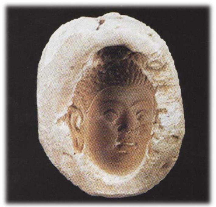
Flourishing of the city falls on Kushan period, i.e. I-III centuries A.D. During this period the city occupies the area of 350 ha. However, in terms of internal housing development it was somewhat dispersed. Numerous monumental buildings of public nature are constructed in the city. In Kushan period Termez becomes the center of Bactria. Many buildings are erected, which are associated with Buddhism. In the north-western outskirts of the city a massive Buddhist center, Qoratepa, gets formed, which unites more than three dozens of temples and monasteries. Not far from Qoratepa another monumental building is erected, i.e. Fayoztepa monastery. The interiors of the monasteries and temples were ornately decorated with murals, stone and clay-ganch sculptures. All these findings are nowadays acknowledged worldwide. And transformation of Termez into the center of Buddhism and Buddhist artistic culture was the result of its becoming part of Kushan state, which created suitable conditions for traveling of Buddhist missionaries in the vast territory of the state and for spreading this religious teaching far beyond India. The objects of artistic culture, which were found in Termez, have direct links with the monuments of ancient India.
At present there is every reason to believe that Buddhist missionaries were natives of India. In support of this assumption speaks the discovery in Buddhist monuments of Termez of many vessels with inscriptions made in Kharoshti and Brami scripts, which mention about the monks of Indian descent. Later, Buddhist monks in Termez were represented by the natives of Bactria. Chinese historical chronicles preserved the names of many Bactrian missionaries, who played an important role in disseminating Buddhist ideas and Buddhist artistic culture in Eastern Turkestan and China. From among them there were the natives of Tarmita (i.e. Termez). For example, in the medieval Tibetan colophon a famous scholar of Buddhist teachings, Dharmamitra from Tarmita, is mentioned. And there is every reason to believe that Buddhist missionaries from Bactria reached China through the southern branch (route) of the Great Silk Roads.
After the downfall of Kushan Empire the city life falls into disrepair. In the early Middle Ages Termez turns into the center of the small possession, the rulers of which mint coins with the image of the ruler full-face, and on the back side – tamga in the form of an anchor. Probably, by doing so local rulers wanted to tell that the city was still one of the port cities on the Amu Darya River.
The second peak in development of the city falls on the ruling period of the Samanids, Ghaznavids, Seljuqs and Karakhanids. During this time the whole territory of the city was intensively made habitable. Many public and residential buildings were constructed. Though, the center of economic life of the city moves to the territory of rabad. Here richly decorated mosques, caravanserais are erected, handicrafts centers emerge. Total area of the city in that period exceeded 50 ha.

Main source, which ensured flourishing of Termez in the X – beginning of the XIII century was external trade. The author of “Hudud al-Alam” mentioned, that Termez was a trade center of Khutalan and Chaghanian. Termez treasury generated significant income through inter-regional caravan trade. Termez rulers paid great attention to the construction of caravanserais within the city, which were offering their services to merchants and traders. Reconnaissance study of the city demonstrated that caravanserais were concentrated in the territory of rabad. It was here that the remains of more than ten caravanserais were discovered. One of them was fully excavated. Architectural-planning structure of the caravanserai is almost identical to other buildings of this type, which are known in Central Asia. At the same time a peculiar feature of caravanserai in Termez was in the fact that it had special rooms – stores for merchants. According to Al-Maqdisi, Termez exported asafetida, various soaps and ships (Al-Maqdisi ). Asafetida was not only used in medicine. It was also widely used as a vegetable herb in the Middle East and India.
In 1220 Termez was destroyed by Tatar-Mongol troops led by Genghis Khan. According to Juvayni, the people of Termez demonstrated a strong resistance to the invaders. The city assault lasted for 10 days. Maybe because of this brave resistance to the enemies Termez was given another epithet - “The City of Brave Men”.
REFERENCES
- Adylova Sh. T. Stratigraphic excavations in ancient site of Poykand. // Ancient site of Poykand. Concerning the challenges in studying the medieval city of Central Asia. Tashkent, 1988 (in Russian).
- Buryakov Y.F., Bogomolov G.I. // Archaeology of Tashkent Oasis, 2009 (in Russian).
- Muhammadjonov L.R. Conclusion. // Ancient site of Poykand. Concerning the challenges in studying the medieval city of Central Asia. Tashkent, 1988 (in Russian).
- Narshakhi. The History of Bukhara. Tashkent, 1966 (in Russian).
- Descriptio imperii moslemici aucfore Schamsoddin Abu Abdallax Мahammad ibn Axmad ibn abi Bekral-Banna al Basschari al-Mokaddasi. Ed. M.J.de Yoeje, Lugduni:. Batavorum, 1877. Ed.r., 1906 (BGA, III) (in Italian).